All Projects → humangeo → Leaflet Tilefilter

humangeo / Leaflet Tilefilter

Licence: mit
Change the appearance of Leaflet map tiles on the fly using a variety of canvas or CSS3 image filters. It's like Instagram for Leaflet map tiles.

Programming Languages

javascript
184084 projects - #8 most used programming language

Projects that are alternatives of or similar to Leaflet Tilefilter

Maps Api For Javascript Examples
Self-contained examples for Maps API for JavaScript v3.
Stars: ✭ 130 (+44.44%)
Mutual labels:  mapping, geospatial, maps
Examples
Self-contained examples for the legacy Maps API for JavaScript.
Stars: ✭ 78 (-13.33%)
Mutual labels:  mapping, geospatial, maps
Editor
An open source visual editor for the 'Mapbox Style Specification'
Stars: ✭ 1,167 (+1196.67%)
Mutual labels:  mapping, geospatial, maps
Leaflet Dvf
Leaflet Data Visualization Framework
Stars: ✭ 678 (+653.33%)
Mutual labels:  mapping, geospatial, maps
Openrailwaymap
An OpenStreetMap-based project for creating a map of the world's railway infrastructure.
Stars: ✭ 150 (+66.67%)
Mutual labels:  mapping, geospatial, maps
jsfiddle-github
JSFiddle implementation for interactive JavaScript examples.
Stars: ✭ 16 (-82.22%)
Mutual labels:  maps, mapping, geospatial
Mapper
OpenOrienteering Mapper is a software for creating maps for the orienteering sport.
Stars: ✭ 258 (+186.67%)
Mutual labels:  mapping, geospatial, maps
Worldwindjava
The NASA WorldWind Java SDK (WWJ) is for building cross-platform 3D geospatial desktop applications in Java.
Stars: ✭ 526 (+484.44%)
Mutual labels:  geospatial, maps
Mapsui
Mapsui is a .NET Map component for WPF, Xamarin.Forms, Xamarin.Android, Xamarin.iOS and UWP
Stars: ✭ 447 (+396.67%)
Mutual labels:  mapping, geospatial
Mapserver
Source code of the MapServer project. Please submit pull requests to the 'main' branch.
Stars: ✭ 693 (+670%)
Mutual labels:  mapping, geospatial
Svg World Map
🗺 A JavaScript library to easily integrate one or more SVG world maps with all nations (countries) and second-level political subdivisions (countries, provinces, states).
Stars: ✭ 38 (-57.78%)
Mutual labels:  mapping, maps
Wicket
A modest library for moving between Well-Known Text (WKT) and various framework geometries
Stars: ✭ 484 (+437.78%)
Mutual labels:  mapping, geospatial
Gmt
The Generic Mapping Tools
Stars: ✭ 468 (+420%)
Mutual labels:  mapping, geospatial
Leaflet.freedraw
🌏 FreeDraw allows the free-hand drawing of shapes on your Leaflet.js map layer – providing an intuitive and familiar UX for creating geospatial boundaries similar to Zoopla and others. Included out-of-the-box is the concaving of polygons, polygon merging and simplifying, as well as the ability to add edges and modify existing shapes.
Stars: ✭ 446 (+395.56%)
Mutual labels:  geospatial, maps
Agentmaps
Make social simulations on interactive maps with Javascript! Agent-based modeling for the web.
Stars: ✭ 822 (+813.33%)
Mutual labels:  geospatial, maps
Lenz
Console based MAP 🗺 : with lots of features 🤩
Stars: ✭ 51 (-43.33%)
Mutual labels:  mapping, maps
Geemap
A Python package for interactive mapping with Google Earth Engine, ipyleaflet, and folium
Stars: ✭ 959 (+965.56%)
Mutual labels:  mapping, geospatial
Gwt Ol
GWT wrapper for OpenLayers 3+ using JSInterop
Stars: ✭ 57 (-36.67%)
Mutual labels:  mapping, maps
Geotiff.io
Static website for viewing and analyzing GeoTIFF's in the browser
Stars: ✭ 53 (-41.11%)
Mutual labels:  geospatial, maps
Geoswift
The Swift Geometry Engine.
Stars: ✭ 1,267 (+1307.78%)
Mutual labels:  geospatial, maps

Leaflet.TileLayer.Filter

Filters Example

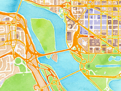
Are you bored with the basic, free tile map services out there, or have you ever wanted to change their base offerings to fit in better with your app?

Do you want the appearance of custom map tiles without having to setup your own tile server? Spice up your maps by adding customizable image filters to tile images. Use one of the existing, free tile providers like MapQuest, OSM, Stamen, and others, then change up their default offerings by adjusting the colors/styling on the client end.

This plugin extends L.TileLayer based classes, adding support for tile image filters. It provides extensible canvas-based filter approaches as well as CSS3 image filters. Canvas filters can be chained together and combined with one or more CSS3 image filters, allowing for many variations. It was originally inspired by Ilya Zverev's Leaflet.TileLayer.Grayscale plug-in, but modified to be more extensible, supporting more than just a grayscale tile filter.

Build

npm install
bower install
grunt

Basic Usage

var baseLayer = new L.TileLayer('http://otile1.mqcdn.com/tiles/1.0.0/map/{z}/{x}/{y}.jpg', {
	filter: function () {
		new L.CSSFilter(this, {
			filters: ['saturate(200%)']
		}).render();
	}
});

var baseLayer = new L.StamenTileLayer('toner');

baseLayer.setFilter(function () {
	new L.CanvasFilter(this, {
		channelFilter: function (imageData) {
			return new L.CanvasChannelFilters.Colorize(imageData, {
				values: [100, 100]
			}).render();
		}
	}).render();
});

Demo

http://humangeo.github.io/leaflet-tilefilter/demo.html

Details

Read the docs. Checkout the 1.0dev branch for Leaflet 1.x support.

Note that the project description data, including the texts, logos, images, and/or trademarks, for each open source project belongs to its rightful owner. If you wish to add or remove any projects, please contact us at [email protected].