MikesWei / Cesiumvectortile
Licence: apache-2.0
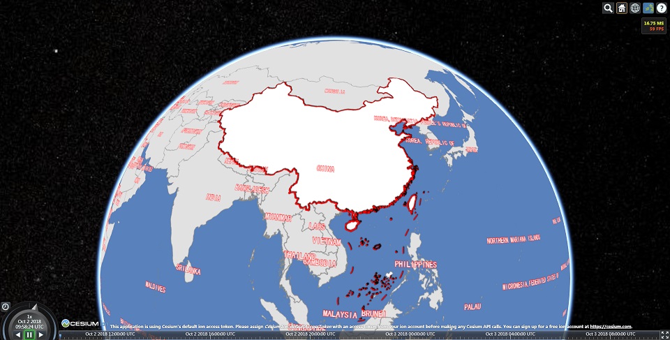
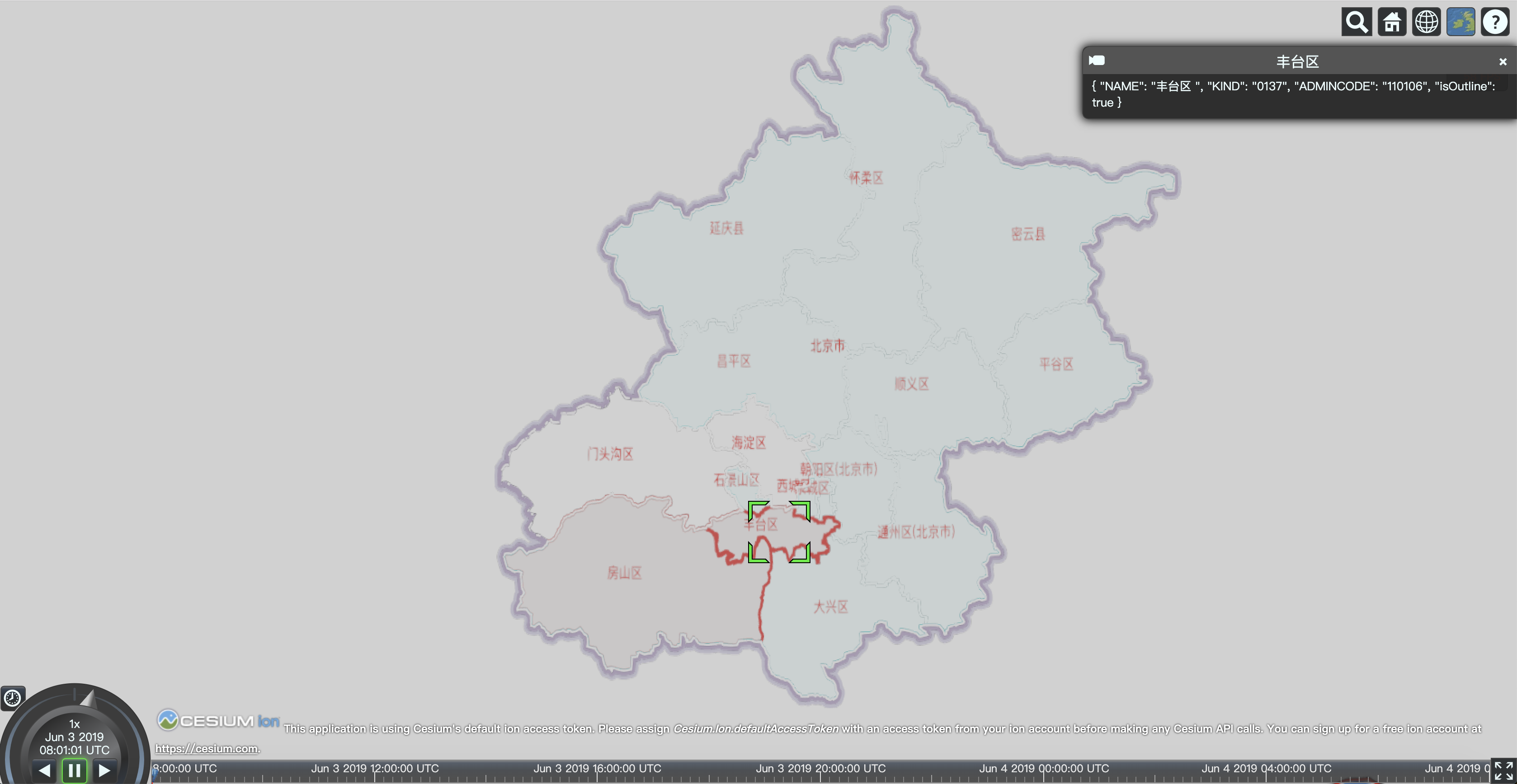
Cesium VectorTileImageryProvider支持小数据量的geojson、shape文件 矢量 动态切片,实现贴地
Stars: ✭ 205
Programming Languages
javascript
184084 projects - #8 most used programming language
Labels
Projects that are alternatives of or similar to Cesiumvectortile
Cesium Google Earth Examples
Google Earth plugin API samples ported to Cesium
Stars: ✭ 73 (-64.39%)
Mutual labels: cesium
Quantized Mesh
Specification for streaming massive terrain datasets for 3D visualization.
Stars: ✭ 139 (-32.2%)
Mutual labels: cesium
Pts
Quantized Mesh Terrain Data Generator and Server for CesiumJS Library
Stars: ✭ 36 (-82.44%)
Mutual labels: cesium
Cesium
cesium demo,cesium 研究过程中资料整理,包括: 1、示例,提供常规的cesium示例以及综合性的业务示例 2、工具,整理研究过程中写的一些数据获取、处理、分析的工具,例如网络3dtiles数据爬虫工具、b3dm 转 gltf工具 3、插件,根据研究过程中cesium感觉使用不方便的地方,添加插件,包括针对显示控件的汉化中文语言插件等
Stars: ✭ 84 (-59.02%)
Mutual labels: cesium
Xbsjearthui
XbsjEarthUI是基于Cesium和EarthSDK的三维GIS/BIM的UI模板,可以基于此定制自己的三维App
Stars: ✭ 373 (+81.95%)
Mutual labels: cesium
Py3dtiles
⚠️ Project migrated to : https://gitlab.com/Oslandia/py3dtiles ⚠️
Stars: ✭ 152 (-25.85%)
Mutual labels: cesium
Satvis
Satellite orbit visualization and pass prediction with Cesium.js
Stars: ✭ 68 (-66.83%)
Mutual labels: cesium
Cesium.hpuzyz.demo
This project is some demos of CESIUM. Much of them are from other people's blogs and cesium's official website (https://cesiumjs.org/tutorials/cesium-up-and-running/). Thanks to my good friend MikesWei (https://github.com/MikesWei) for giving me great help.
Stars: ✭ 681 (+232.2%)
Mutual labels: cesium
Cesium
An open-source JavaScript library for world-class 3D globes and maps 🌎
Stars: ✭ 8,095 (+3848.78%)
Mutual labels: cesium
Iclient Javascript
Modern GIS Web Client for JavaScript, based on Leaflet\OpenLayers\MapboxGL-JS\Classic(iClient8C), enhanced with ECharts\D3\MapV etc. Contributed by SuperMap & community.
Stars: ✭ 593 (+189.27%)
Mutual labels: cesium
Angular Cesium
JavaScript library for creating map based web apps using Cesium and Angular
Stars: ✭ 141 (-31.22%)
Mutual labels: cesium
Tin Terrain
A command-line tool for converting heightmaps in GeoTIFF format into tiled optimized meshes.
Stars: ✭ 392 (+91.22%)
Mutual labels: cesium
Cesium Point Cloud Generator
A small Java-based tool for the generation of point cloud visualization datasets according to Cesium 3D Tiles.
Stars: ✭ 82 (-60%)
Mutual labels: cesium
Cesiumjs Tutorial
CesiumJS中文基础教程 http://cesiumcn.org/ | http://cesium.coinidea.com/
Stars: ✭ 148 (-27.8%)
Mutual labels: cesium
Webclient Javascript
MapGIS Client for JavaScript, is a cloud GIS network client development platform. It makes a perfect fusion of traditional WebGIS and cloud GIS; also integrates four mainstream map open source frameworks and visualization libraries such as Echarts, MapV, and D3, etc.. Therefore, highly-efficient visual expression and analysis of big data and real-time streaming data have been further enhanced.
Stars: ✭ 88 (-57.07%)
Mutual labels: cesium
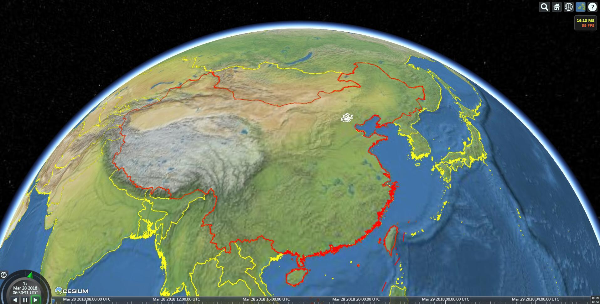
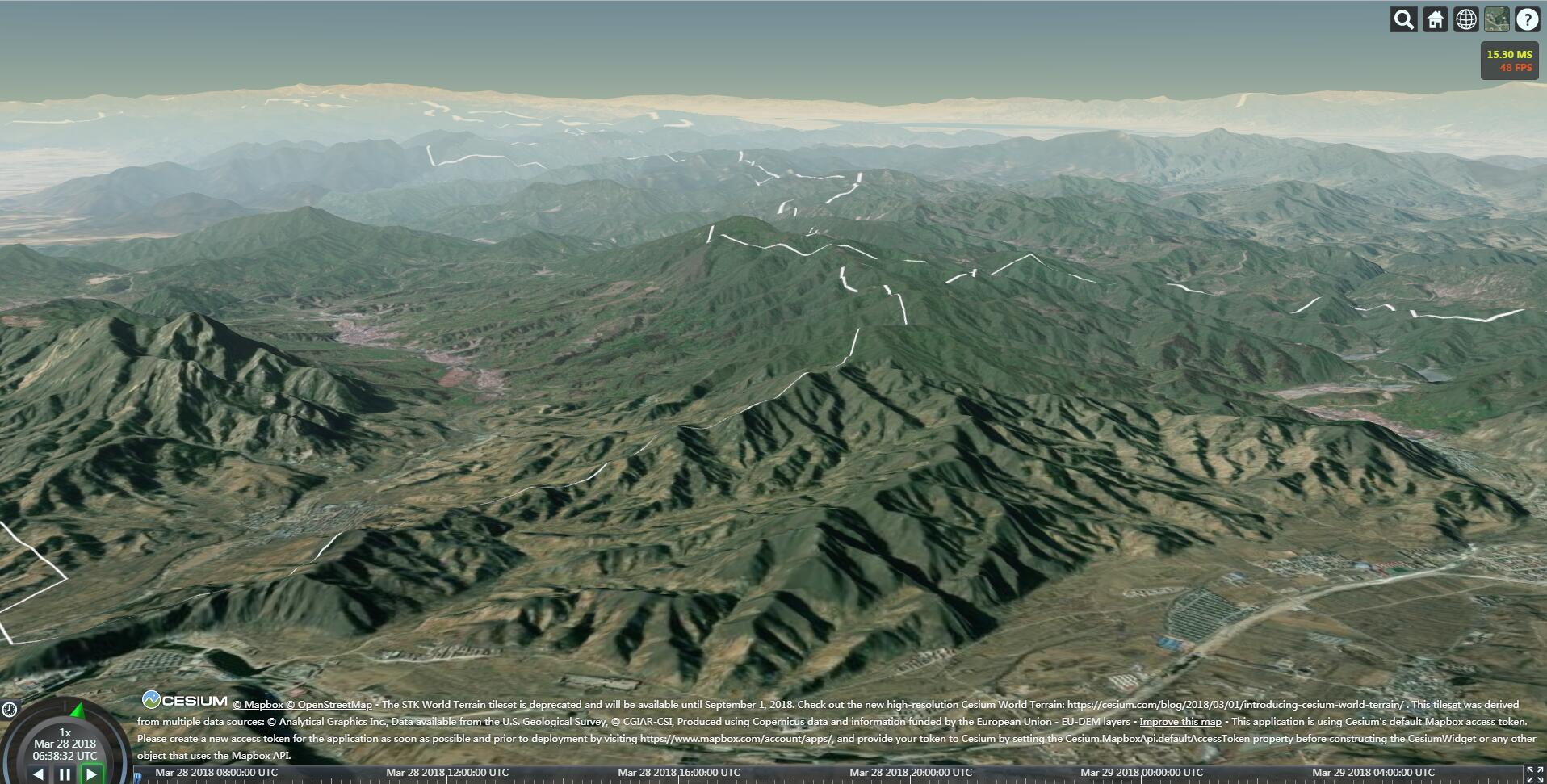
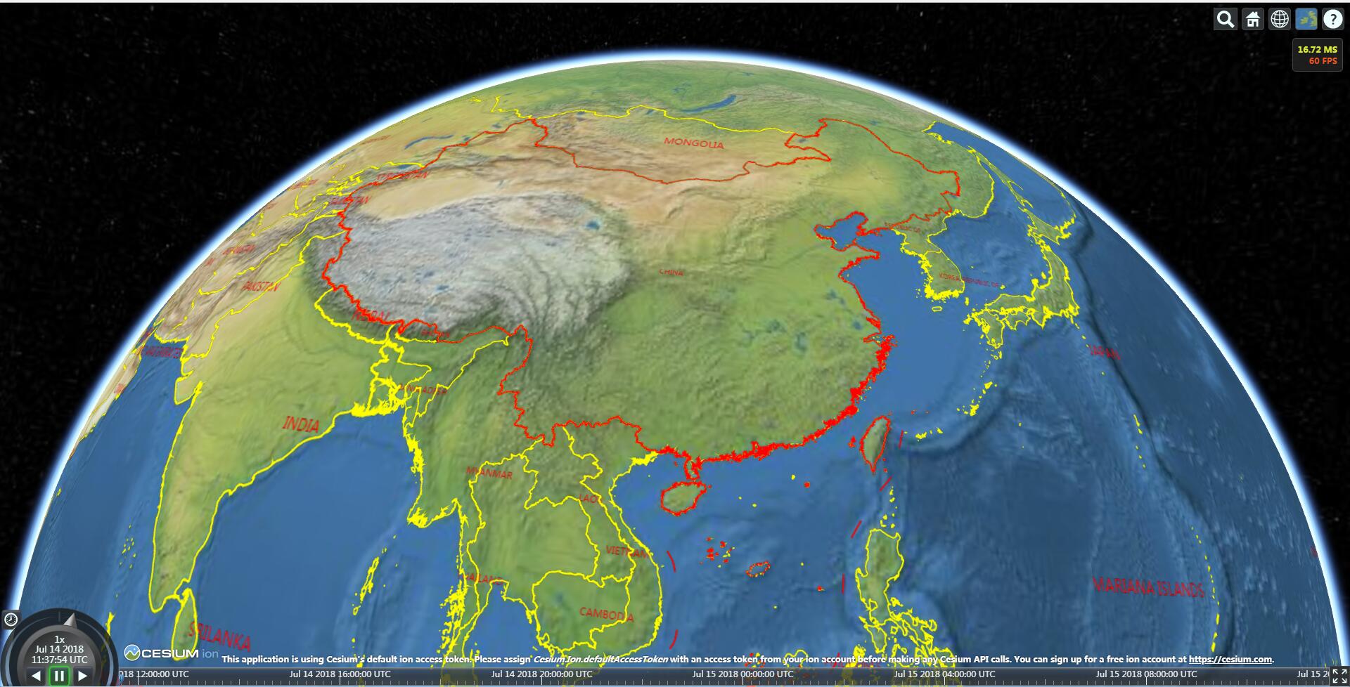
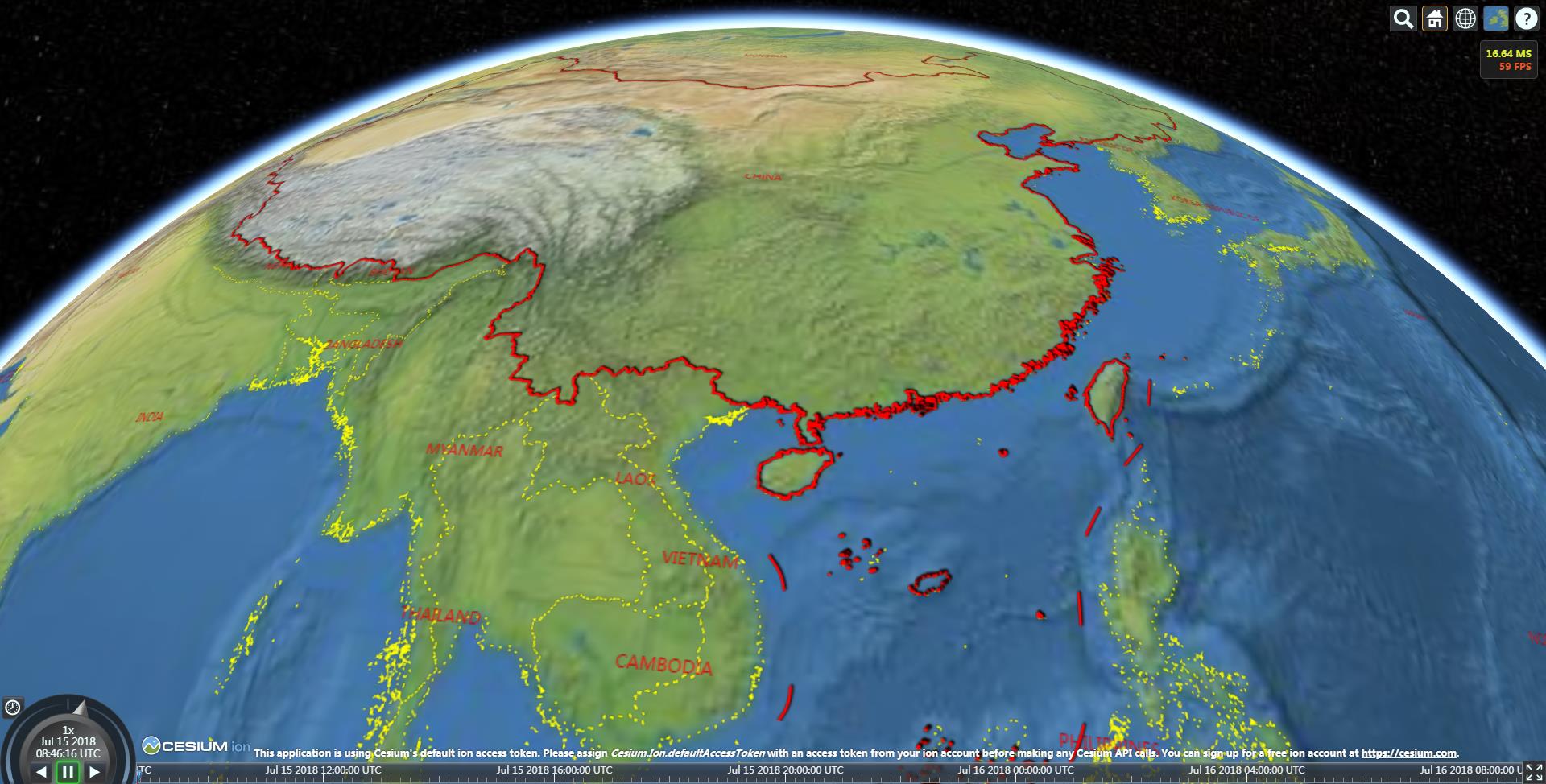
Cesium VectorTileImageryProvider
支持小数据量的geojson、shape文件矢量动态切片,实现贴地
npm 安装
npm install cesiumvectortile
示例:
        VectorTileImageryProvider = Cesium.VectorTileImageryProvider;

        viewer = new Cesium.Viewer("cesiumContainer");
        var imageryProviderViewModels = viewer.baseLayerPicker.viewModel.imageryProviderViewModels;
        viewer.baseLayerPicker.viewModel.selectedImagery = imageryProviderViewModels[imageryProviderViewModels.length - 1];
        viewer.scene.debugShowFramesPerSecond = true;

        var provinceLayer = null;
        var provinceProvider = new VectorTileImageryProvider({
            source: appConfig.BaseURL + "Assets/Data/json/china_province.geojson",
            defaultStyle: {
                outlineColor: "rgb(255,255,255)",
                lineWidth: 2,
                fill: false,
                tileCacheSize: 200
            },
            maximumLevel: 20,
            minimumLevel: 1,
            simplify: false
        });
        provinceProvider.readyPromise.then(function () {
            provinceLayer = viewer.imageryLayers.addImageryProvider(provinceProvider);
        });

        var worldLayer = null;
        var worldProvider = new VectorTileImageryProvider({
            source: appConfig.BaseURL + "Assets/Data/shp/world/国家简化边界.shp",
            defaultStyle: {
                outlineColor: "rgb(255,0,0)",
                lineWidth: 1,
                fill: false,
                tileCacheSize: 200,
                showMaker: false,
                showCenterLabel: true,
                fontColor: "rgba(255,0,0,1)",
                labelOffsetX: -10,
                labelOffsetY: -5,
                fontSize: 13,
                fontFamily: "黑体",
                centerLabelPropertyName: "NAME"
            },
            maximumLevel: 20,
            minimumLevel: 1,
            simplify: false
        });
        worldProvider.readyPromise.then(function () {
            worldLayer = viewer.imageryLayers.addImageryProvider(worldProvider);
        });
依赖
更新
2019.06.03
- 1、支持要素查询:增加构造函数可选参数allowPick,事件featuresPicked
2018.07.15:
- 1、支持虚线和阴影
2018.07.14:
- 1、支持最新版Cesium;
- 2、支持以注记的方式显示关键属性,如地名等。
Note that the project description data, including the texts, logos, images, and/or trademarks,
for each open source project belongs to its rightful owner.
If you wish to add or remove any projects, please contact us at [email protected].