All Projects → iliatimofeev → gpdvega

iliatimofeev / gpdvega

Licence: BSD-3-Clause license
gpdvega is a bridge between GeoPandas and Altair that allows to seamlessly chart geospatial data

Programming Languages

python
139335 projects - #7 most used programming language
Makefile
30231 projects

Projects that are alternatives of or similar to gpdvega

census-map-consolidator
Combine Census blocks into new shapes
Stars: ✭ 31 (-36.73%)
Mutual labels:  geopandas
Python-Geopandas-Workshop
In this workshop you will learn about pandas and geopandas by exploring UK Crime Data in a Jupyter notebook
Stars: ✭ 52 (+6.12%)
Mutual labels:  geopandas
geopandas-spatial-join-example
An example of how to join point to polygon data with geopandas and Python
Stars: ✭ 21 (-57.14%)
Mutual labels:  geopandas
data-analysis-using-python
Data Analysis Using Python: A Beginner’s Guide Featuring NYC Open Data
Stars: ✭ 81 (+65.31%)
Mutual labels:  geopandas
coronavirus-ds
Jupyter notebooks and python scripts for investigating the 2019 coronavirus outbreak
Stars: ✭ 31 (-36.73%)
Mutual labels:  geopandas
movingpandas-examples
Example notebooks illustrating MovingPandas use cases
Stars: ✭ 116 (+136.73%)
Mutual labels:  geopandas
GeoUtils
Class-based handling of georeferenced raster and vector data
Stars: ✭ 32 (-34.69%)
Mutual labels:  geopandas
Altair
✨⚡️ A beautiful feature-rich GraphQL Client for all platforms.
Stars: ✭ 3,827 (+7710.2%)
Mutual labels:  altair
examples
Example nteract notebooks with links to execution on mybinder.org
Stars: ✭ 24 (-51.02%)
Mutual labels:  altair
Interactive-Data-Visualization-with-Python
Present your data as an effective and compelling story
Stars: ✭ 71 (+44.9%)
Mutual labels:  altair
streamlit-vega-lite
A Streamlit component to render interactive Vega, Vega-Lite, and Altair visualizations and access the selected data from Python
Stars: ✭ 59 (+20.41%)
Mutual labels:  altair
covidviz
Professional visualizations of COVID-19, emulating NYT, The Guardian, Washington Post, The Economist & others, using only Python & Altair.
Stars: ✭ 24 (-51.02%)
Mutual labels:  altair
flasked-altair
Altair/Vega-Lite + Flask for easy web visuals
Stars: ✭ 50 (+2.04%)
Mutual labels:  altair
covid19-italy
Quick streamlit dashboard to visualise the impact of COVID-19 in Italy
Stars: ✭ 24 (-51.02%)
Mutual labels:  altair
terminus-altair
Elegant customizable theme with vivid colors for Terminus
Stars: ✭ 26 (-46.94%)
Mutual labels:  altair

gpdvega Coverage Status Build Status HitCount GitHub license GitHub issues

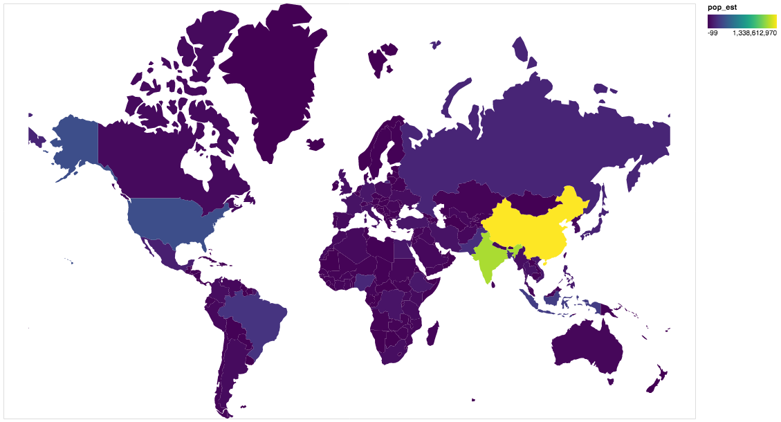
gpdvega is a bridge between GeoPandas a geospatial extension of Pandas and the declarative statistical visualization library Altair, which allows to seamlessly chart geospatial data using altair.

Example

import altair as alt
import geopandas as gpd
import gpdvega

alt.renderers.enable('notebook') # render for Jupyter Notebook

world = gpd.read_file(gpd.datasets.get_path('naturalearth_lowres'))

# GeoDataFrame could be passed as usual pd.DataFrame
alt.Chart(world[world.continent!='Antarctica']).mark_geoshape(
).project(
).encode(
    color='pop_est', # shorthand infer types as for regular pd.DataFrame
    tooltip='id:Q' # GeoDataFrame.index is accessible as id
).properties(
    width=500,
    height=300
)

output

Install

Dependencies

gpdvega requires:

  • Altair (>= 2.2.0 )
  • GeoPandas (>= 0.4.0)

User installation

using pip

pip install gpdvega

Changelog

See the changelog for a history of notable changes to gpdvega

Note that the project description data, including the texts, logos, images, and/or trademarks, for each open source project belongs to its rightful owner. If you wish to add or remove any projects, please contact us at [email protected].