All Projects → inigodelportillo → ITU-Rpy

inigodelportillo / ITU-Rpy

Licence: MIT License
A python implementation of the ITU-R P. Recommendations for atmospheric attenuation modeling

Programming Languages

python
139335 projects - #7 most used programming language

Projects that are alternatives of or similar to ITU-Rpy

rio-glui
Explore CloudOptimized geotiff on your browser using Mapbox GL JS
Stars: ✭ 47 (-21.67%)
Mutual labels:  satellite
cesium-satellites
View the orbit of satellites in a Cesium viewer, derived from a two line element list
Stars: ✭ 45 (-25%)
Mutual labels:  satellite
rio-toa
Top Of Atmosphere (TOA) calculations for Landsat 8
Stars: ✭ 38 (-36.67%)
Mutual labels:  satellite
gribr
GRIB interface for R using ECMWF ecCodes
Stars: ✭ 18 (-70%)
Mutual labels:  atmospheric-modelling
oresat-linux
OreSat Linux image builder, general embedded Linux documentation, and general utilities.
Stars: ✭ 12 (-80%)
Mutual labels:  satellite
miq-RedHat-Satellite6
ManageIQ Automate Domain for integrating with Red Hat Satellite 6 developed by Red Hat Consulting.
Stars: ✭ 17 (-71.67%)
Mutual labels:  satellite
mptrac
Massive-Parallel Trajectory Calculations (MPTRAC) is a Lagrangian particle dispersion model for the analysis of atmospheric transport processes in the troposphere and stratosphere.
Stars: ✭ 19 (-68.33%)
Mutual labels:  atmospheric-modelling
PySDM
Pythonic particle-based (super-droplet) warm-rain/aqueous-chemistry cloud microphysics package with box, parcel & 1D/2D prescribed-flow examples in Python, Julia and Matlab
Stars: ✭ 26 (-56.67%)
Mutual labels:  atmospheric-modelling
Mercury-GS
An Open Source Program that allows users to interact with a Spacecraft in a lab environment, pre-launch.
Stars: ✭ 18 (-70%)
Mutual labels:  satellite
PyProSAIL
Python interface to the ProSAIL leaf/canopy reflectance model
Stars: ✭ 15 (-75%)
Mutual labels:  satellite
untiler
Stitch image tiles into larger composite TIFs
Stars: ✭ 35 (-41.67%)
Mutual labels:  satellite
Rnightlights
R package to extract data from satellite nightlights.
Stars: ✭ 45 (-25%)
Mutual labels:  satellite
Presence-Footsteps
An overly complicated footstep sound enhancement mod for Minecraft
Stars: ✭ 79 (+31.67%)
Mutual labels:  atmospheric
SGP.NET
C# SGP4 Satellite Prediction Library. Load satellites from TLEs, convert between coordinate systems and reference frames, observe satellites from ground stations, and more.
Stars: ✭ 15 (-75%)
Mutual labels:  satellite
rio-hist
Histogram matching plugin for rasterio
Stars: ✭ 71 (+18.33%)
Mutual labels:  satellite
satproc
🛰️ Python library and CLI tools for processing geospatial imagery for ML
Stars: ✭ 27 (-55%)
Mutual labels:  satellite
grwave
Python for ITU P.368 : Ground-wave propagation curves for frequencies between 10 kHz and 30 MHz
Stars: ✭ 19 (-68.33%)
Mutual labels:  itu
WorldWeather
The largest three-dimensional web-based interactive browser of satellite, weather, climate, and other time-aware geospatial data on the web, built upon NASA's revolutionary WorldWind technology.
Stars: ✭ 49 (-18.33%)
Mutual labels:  satellite
pyspectral
Pyspectral is a package to read and manipulate satellite sensor spectral responses and solar irradiance spectra
Stars: ✭ 44 (-26.67%)
Mutual labels:  satellite
LBLRTM
Line-By-Line Radiative Transfer Model by Atmospheric and Environmental Research
Stars: ✭ 33 (-45%)
Mutual labels:  atmospheric-modelling

ITU-Rpy

GitHub license Build Status PyPI version codecov PyPI pyversions Documentation Status

A python implementation of the ITU-R P. Recommendations to compute atmospheric attenuation in slant and horizontal paths.

The propagation loss on an Earth-space path and a horizontal-path, relative to the free-space loss, is the sum of different contributions, namely: attenuation by atmospheric gases; attenuation by rain, other precipitation and clouds; scintillation and multipath effects; attenuation by sand and dust storms. Each of these contributions has its own characteristics as a function of frequency, geographic location and elevation angle. ITU-Rpy allows for fast, vectorial computation of the different contributions to the atmospheric attenuation.

Documentation

The documentation can be found at ITU-Rpy documentation in Read the docs.

Examples of use cases can be found in the examples folder.

Installation

ITU-Rpy has the followind dependencies: numpy, scipy, pyproj, and astropy. Installation of cartopy and matplotlib is recommended to display results in a map.

Using pip, you can install all of them by running:

pip install itur

More information about the installation process can be found on the documentation.

ITU-R Recommendations implemented

The following ITU-R Recommendations are implemented in ITU-Rpy

  • ITU-R P.453-13: The radio refractive index: its formula and refractivity data
  • ITU-R P.530-17: Propagation data and prediction methods required for the design of terrestrial line-of-sight systems
  • ITU-R P.618-13: Propagation data and prediction methods required for the design of Earth-space telecommunication systems
  • ITU-R P.676-12: Attenuation by atmospheric gases
  • ITU-R P.835-6: Reference Standard Atmospheres
  • ITU-R P.836-6: Water vapour: surface density and total columnar content
  • ITU-R P.837-7: Characteristics of precipitation for propagation modelling
  • ITU-R P.838-3: Specific attenuation model for rain for use in prediction methods
  • ITU-R P.839-4: Rain height model for prediction methods.
  • ITU-R P.840-8: Attenuation due to clouds and fog
  • ITU-R P.1144-10: Interpolation methods for the geophysical properties used to compute propagation effects
  • ITU-R P.1510-1: Mean surface temperature
  • ITU-R P.1511-2: Topography for Earth-to-space propagation modelling
  • ITU-R P.1623-1: Prediction method of fade dynamics on Earth-space paths
  • ITU-R P.1853-1: Tropospheric attenuation time series synthesis

The individual models can be accessed using the itur.models package.

Usage

The following code example shows the usage of ITU-Rpy. More examples can be found in the examples folder.

import itur

f = 22.5 * itur.u.GHz    # Link frequency
D = 1 * itur.u.m         # Size of the receiver antenna
el = 60                  # Elevation angle constant of 60 degrees
p = 3                    # Percentage of time that attenuation values are exceeded.
	
# Generate a regular grid latitude and longitude points with 1 degrees resolution	
lat, lon = itur.utils.regular_lat_lon_grid() 

# Comute the atmospheric attenuation
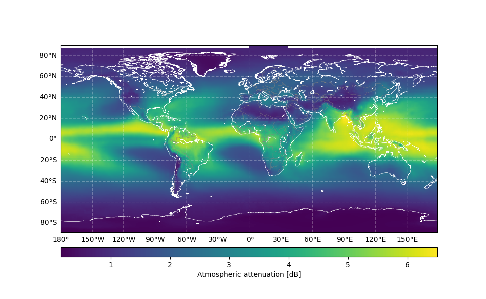
Att = itur.atmospheric_attenuation_slant_path(lat, lon, f, el, p, D) 
itur.plotting.plot_in_map(Att.value, lat, lon, 
                          cbar_text='Atmospheric attenuation [dB]')

which produces: Attenuation worldmap

Validation

ITU-Rpy has been validated using the ITU Validation examples (rev 5.1) , which provides test cases for parts of Recommendations ITU-R P.453-14, P.618-13, P.676-12, P.836-6, P.837-7, P.838-3, P.839-4, P.840-8, P.1511-2, P.1623-1.

The results of this validation exercise are available at the validation page in the documentation.

Citation

If you use ITU-Rpy in one of your research projects, please cite it as:

@misc{iturpy-2017,
      title={ITU-Rpy: A python implementation of the ITU-R P. Recommendations to compute atmospheric
	     attenuation in slant and horizontal paths.},
      author={Inigo del Portillo},
      year={2017},
      publisher={GitHub},
      howpublished={\url{https://github.com/inigodelportillo/ITU-Rpy/}}
}
Note that the project description data, including the texts, logos, images, and/or trademarks, for each open source project belongs to its rightful owner. If you wish to add or remove any projects, please contact us at [email protected].