All Projects → tsupinie → vad-plotter

tsupinie / vad-plotter

Licence: GPL-2.0 license
Plotter for NEXRAD VWP retrievals.

Programming Languages

python
139335 projects - #7 most used programming language

Projects that are alternatives of or similar to vad-plotter

go-pairplot
No description or website provided.
Stars: ✭ 38 (+111.11%)
Mutual labels:  plotter
ecPoint-Calibrate
Interactive GUI (developed in Python) for calibration and conditional verification of numerical weather prediction model outputs.
Stars: ✭ 19 (+5.56%)
Mutual labels:  meteorology
grbl-mega-wall-plotter
(WIP) A variant of Grbl (v1.1g) for Arduino Mega with support for hanging wall plotters
Stars: ✭ 15 (-16.67%)
Mutual labels:  plotter
core
Create 2d primitive shapes, encapsulate and repeat them by handling each repetition and generate recursive shapes
Stars: ✭ 34 (+88.89%)
Mutual labels:  plotter
grib-rs
GRIB format parser for Rust
Stars: ✭ 23 (+27.78%)
Mutual labels:  meteorology
go-nexrad
NEXRAD Data Processing with Go
Stars: ✭ 19 (+5.56%)
Mutual labels:  nexrad
climate-data-science
Climate Data Science and Earth Observation with Python.
Stars: ✭ 103 (+472.22%)
Mutual labels:  meteorology
python-awips
A framework for querying AWIPS meteorological datasets from an EDEX Data Server.
Stars: ✭ 31 (+72.22%)
Mutual labels:  meteorology
mptrac
Massive-Parallel Trajectory Calculations (MPTRAC) is a Lagrangian particle dispersion model for the analysis of atmospheric transport processes in the troposphere and stratosphere.
Stars: ✭ 19 (+5.56%)
Mutual labels:  meteorology
spokestack-ios
Spokestack: give your iOS app a voice interface!
Stars: ✭ 27 (+50%)
Mutual labels:  vad
isovoxel
Isometric voxel generative art
Stars: ✭ 60 (+233.33%)
Mutual labels:  plotter
forest
FOREST - Forecast and Observation Research and Evaluation Survey Tool
Stars: ✭ 31 (+72.22%)
Mutual labels:  meteorology
cobra
On-device voice activity detection (VAD) powered by deep learning.
Stars: ✭ 76 (+322.22%)
Mutual labels:  vad
python-webrtc-audio-processing
Python bindings of WebRTC Audio Processing
Stars: ✭ 140 (+677.78%)
Mutual labels:  vad
improver
IMPROVER is a library of algorithms for meteorological post-processing.
Stars: ✭ 76 (+322.22%)
Mutual labels:  meteorology
antenna analyzer vna
Pocket Arduino Nano based graphical SWR 160-6m bands panoramic VNA antenna analyzer based on AD9850, AD8302 and SGA3386
Stars: ✭ 17 (-5.56%)
Mutual labels:  plotter
wetterdienst
Open weather data for humans
Stars: ✭ 190 (+955.56%)
Mutual labels:  meteorology
Vad
android vad library base on webrtc vad
Stars: ✭ 24 (+33.33%)
Mutual labels:  vad
object centric VAD
An Tensorflow Re-Implement of CVPR 2019 "Object-centric Auto-Encoders and Dummy Anomalies for Abnormal Event Detection in Video"
Stars: ✭ 89 (+394.44%)
Mutual labels:  vad
gribr
GRIB interface for R using ECMWF ecCodes
Stars: ✭ 18 (+0%)
Mutual labels:  meteorology

vad-plotter

Parser and plotter for NEXRAD VAD retrievals.

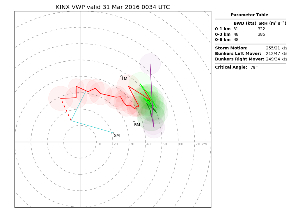
The script downloads the VAD data from the NEXRAD Radar Product Dissemination page, parses the binary file, and plots the VAD retrieval as a hodograph. It also computes and displays some parameters of interest.

Required Libraries

NumPy and Matplotlib are the only requirements to run this script.

Usage

python vad.py RADAR_ID [ -m STORM_MOTION ] [ -s SFC_WIND ] [ -t TIME ] [ -f IMG_NAME ] 
                       [ -p LOCAL_PATH ] [ -c CACHE_PATH ]
  • RADAR_ID is a 4-character radar identifier (e.g. KTLX or KFWS). TDWRs (e.g. TDFW or TORD) also work.
  • STORM_MOTION is the storm motion vector. It can take one of two form. The first is either BRM for the Bunkers right-mover vector or BLM for the Bunkers left-mover vector. The second form is DDD/SS, where DDD is the direction the storm is coming from in degrees, and SS is the storm speed in knots. An example might be 240/35 (from the WSW at 35 kts). If the argument is not specified, the default is to use the Bunkers right-mover vector.
  • SFC_WIND is the surface wind vector. Its form is the same as the DDD/SS form of the storm motion vector. A dashed red line will be drawn on the hodograph from the lowest point in the VWP to the surface wind to indicate the approximate wind profile in that layer.
  • TIME is the plot time. It takes the form [YYYY-mm-]dd/HHMM, where YYYY is the 4-digit year, mm is the month, dd is the day, HH is the hour, and MM is the minute. The year and month are optional. The script will plot the most recent VWP as of this time.
  • IMG_NAME is the name of the image the script produces. If not given, it defaults to <RADAR_ID>_vad.png. If you would like a vector image rather than a raster image, give a name with a .pdf file extension.
  • LOCAL_PATH specifies that, instead of downloading VWP data from the Internet, the script should load the VWP data from this path on the local disk. Data are assumed to have been downloaded from NCDC's NEXRAD archive. The name of the file should not be given; the script will construct the file name using the other information.
  • CACHE_PATH is the path to a local directory in which to cache files downloaded from the Internet. The downloaded files can be read in directly using the -p option.

An example of the output is given below. See the interpretation section for more information.

Example VWP Image

Interpretation

A "hodograph" is a graph of wind as a function of height. The u component of the wind is on the x axis and the v component of wind is on the y axis. Area on the hodograph is proportional to helicity, an important parameter in severe convective storm forecasting.

The colors denote different height layers, and follow the Storm Prediction Center's convention for their hodographs: red denotes the 0-3 km layer, light green denotes the 3-6 km layer, dark green denotes the 6-9 km layer, purple denotes the 9-12 km layer, and cyan denotes the layer from 12 km on up. The colored circles are proportional in radius to the RMS error in the VAD retrieval at each level.

When computing the parameters, in the absence of a specified surface wind, the "surface" is taken to be the lowest data point in the VWP, which is often ~100 m AGL.

Note that the project description data, including the texts, logos, images, and/or trademarks, for each open source project belongs to its rightful owner. If you wish to add or remove any projects, please contact us at [email protected].