All Projects → ckoval7 → df-aggregator

ckoval7 / df-aggregator

Licence: GPL-3.0 license
Networked DFing software that can handle multiple DOA receivers.

Programming Languages

python
139335 projects - #7 most used programming language
javascript
184084 projects - #8 most used programming language
Smarty
1635 projects
CSS
56736 projects

Projects that are alternatives of or similar to df-aggregator

geocoder
Geocoder is a Typescript library which helps you build geo-aware applications by providing a powerful abstraction layer for geocoding manipulations
Stars: ✭ 28 (-40.43%)
Mutual labels:  geolocation
m-ld-js
m-ld Javascript engine
Stars: ✭ 18 (-61.7%)
Mutual labels:  rdf
sparklis
Sparklis is a query builder in natural language that allows people to explore and query SPARQL endpoints with all the power of SPARQL and without any knowledge of SPARQL.
Stars: ✭ 28 (-40.43%)
Mutual labels:  rdf
go-dmr
Digital Mobile Radio
Stars: ✭ 53 (+12.77%)
Mutual labels:  ham-radio
Frontend-Learning-Journey
Tutorials, definitions, frameworks and some of the projects i made when starting to learn frontend web developement
Stars: ✭ 28 (-40.43%)
Mutual labels:  geolocation
totalopenstation
Total Open Station downloads and exports survey data from your total station
Stars: ✭ 51 (+8.51%)
Mutual labels:  geolocation
aprs-weather-submit
Manually submit weather station information to the APRS-IS network.
Stars: ✭ 17 (-63.83%)
Mutual labels:  ham-radio
everything
The semantic desktop search engine
Stars: ✭ 22 (-53.19%)
Mutual labels:  rdf
rescue-me
Light-weight and minimalistic system for push-based location requests.
Stars: ✭ 13 (-72.34%)
Mutual labels:  geolocation
svelte-googlemaps
Svelte Google Maps Components
Stars: ✭ 62 (+31.91%)
Mutual labels:  geolocation
LD-Connect
LD Connect is a Linked Data portal for IOS Press in collaboration with the STKO Lab at UC Santa Barbara.
Stars: ✭ 0 (-100%)
Mutual labels:  rdf
ip2location-lua
Use IP2Location geolocation database to lookup the geolocation information with IP2Location Lua Package. It can be used to determine country, region, city, coordinates, zip code, time zone, ISP, domain name, connection type, area code, weather, MCC, MNC, mobile brand name, elevation, usage type, address type and IAB category that any IP address …
Stars: ✭ 14 (-70.21%)
Mutual labels:  geolocation
SolRDF
An RDF plugin for Solr
Stars: ✭ 115 (+144.68%)
Mutual labels:  rdf
QuitStore
🖧 Quads in Git - Distributed Version Control for RDF Knowledge Bases
Stars: ✭ 87 (+85.11%)
Mutual labels:  rdf
SANSA-Stack
Big Data RDF Processing and Analytics Stack built on Apache Spark and Apache Jena http://sansa-stack.github.io/SANSA-Stack/
Stars: ✭ 130 (+176.6%)
Mutual labels:  rdf
GeoLite.mmdb
MaxMind's GeoIP2 GeoLite2 Country, City, and ASN databases
Stars: ✭ 690 (+1368.09%)
Mutual labels:  geolocation
mayktso
🌌 mayktso: encounters at an endpoint
Stars: ✭ 19 (-59.57%)
Mutual labels:  rdf
ember-cli-geo
Geolocation service for Ember.js web apps
Stars: ✭ 48 (+2.13%)
Mutual labels:  geolocation
utils-do
utils-do is a javascript package that provides functionalities that'll easily help you to interact with Dominican Republic's data.
Stars: ✭ 18 (-61.7%)
Mutual labels:  geolocation
skos-play
SKOS-Play allows to print SKOS files in HTML or PDF. It also embeds xls2rdf to generate RDF from Excel.
Stars: ✭ 58 (+23.4%)
Mutual labels:  rdf

DF Aggregator

Recent Changes:

  • Update to CesiumJS 1.95
  • Power and Confidence range sliders have been updated to reflect data output by the KrakenSDR software.
  • Ellipse parameters are now automatically calculated. You can still adjust them if you want, but the auto-calculation works exceptionally well.
  • For previous changes see the Change Log.

Installing:

Dependencies:

Other things you'll need:

  • Cesium Ion Token
    • Create a single line file named accesstoken.txt
    • Turns out you can use a public token, you just can't use Cesium Assets. Most people don't need to use assets.
    • The token is optional with --access_token=accesstoken.txt
  • Preferred: KrakenSDR Software
  • Alternatively: Extended XML KerberosSDR Software
    • This is available for both Qt4 (original version) and Qt5 (Ubuntu 20.04+). Just check out the appropriate branch.

Screenshot

Usage: df-aggregator.py [options]

Required inputs:

  • -d FILE, --database=FILE
    • Name of new or existing database to store intersect information.
    • If a database doesn't exist one is created.
    • Post processing math is done against the entire database.

Optional Inputs:

  • -r FILE, --receivers=FILE

    • List of receiver URLs
    • Do not include quotes. Each receiver should be on a new line.
  • -g FILE, --geofile=FILE

    • GeoJSON Output File
    • Conventional file extension: .geojson
  • -e Number, --epsilon=Number or "auto"

    • Max Clustering Distance, Default "auto".
    • 0 to disable clustering.
    • Point spread across a larger geographical area should require a smaller value.
    • Clustering should be disabled for moving targets.
  • -c Number, --confidence=Number

    • Minimum confidence value, default 10
    • Do not compute intersects for LOBs less than this value.
  • -p Number, --power=Number

    • Minimum power value, default 10
    • Do not compute intersects for LOBs less than this value.
  • -m Number, --min-samples=Number or "auto"

    • Minimum samples per cluster. Default "auto"
    • A higher value can yield more accurate results, but requires more data.
  • --plot_intersects

    • Plots all the intersect points in a cluster.
    • Only applies when clustering is turned on.
    • This creates larger CZML files.
  • -o, --offline

    • Starts program with receiver turned off.
    • Useful for looking at stored data when you can't connect to receivers.
  • --ip=IP ADDRESS

    • IP Address to serve from. Default 127.0.0.1
  • --port=NUMBER

    • Port number to serve from. Default 8080
  • --debug

    • Does not clear the screen. Useful for seeing errors and warnings.

Once the program is running, browse to 127.0.0.1:8080 or whatever IP/Port Number you specified.
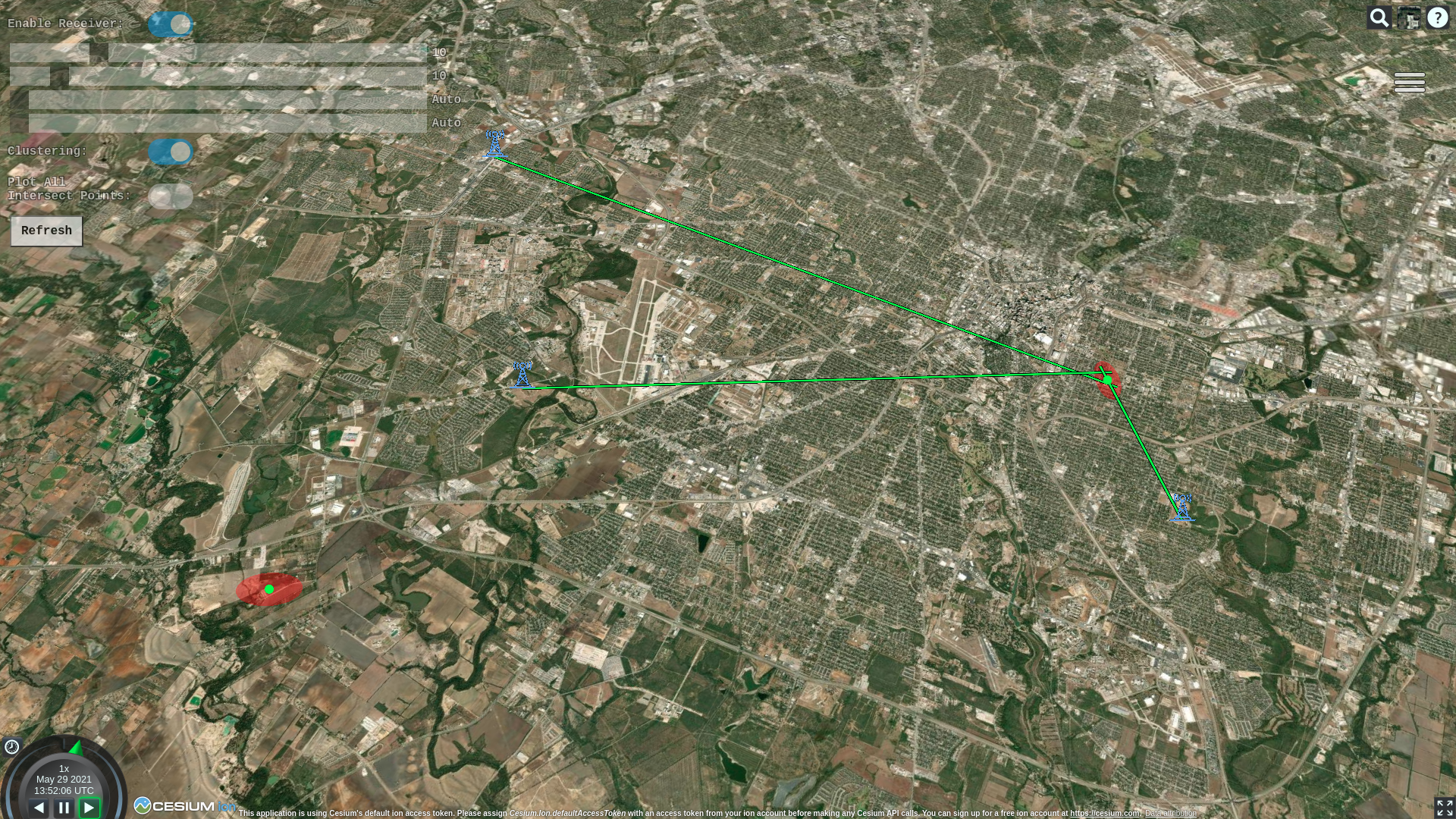
Map Colors:

  • A red ellipse represents the significant majority of the intersections in a particular cluster. It makes up the full area where the transmitter is most certainly located.
  • The large green dot at the center of the ellipse is the likely location of the transmitter. It is simply computed as the mean of all intersections in that cluster.
  • The smaller dots, if turned on vary in color from red to green. These dots are the individual intersections. The color represents the age relative to the full data set. Red is older, green is newer. This is very helpful for following moving targets.
  • LOBs can either be red, orange, or green.
    • Red means neither power nor confidence are above threshold.
    • Orange means either power or confidence, but not both are above threshold.
    • Green means power and confidence are above threshold.

Attributions

Tower and car icons made by Freepik from www.flaticon.com

Note that the project description data, including the texts, logos, images, and/or trademarks, for each open source project belongs to its rightful owner. If you wish to add or remove any projects, please contact us at [email protected].