All Projects → jmlich → geotagging

jmlich / geotagging

Licence: GPL-3.0 license
Photography geotagging tool

Programming Languages

javascript
184084 projects - #8 most used programming language
C++
36643 projects - #6 most used programming language
CSS
56736 projects
CMake
9771 projects
HTML
75241 projects

Projects that are alternatives of or similar to geotagging

Exiftool Vendored.js
Fast, cross-platform Node.js access to ExifTool
Stars: ✭ 200 (+1076.47%)
Mutual labels:  gps, exif
Exifr
📷 The fastest and most versatile JS EXIF reading library.
Stars: ✭ 448 (+2535.29%)
Mutual labels:  gps, exif
gamestudio
2D game engine and editor
Stars: ✭ 207 (+1117.65%)
Mutual labels:  qt5
CoronaTracker
A full stack framework to trace possible close-contact candidates within last specified days for an already detected covid-19 positive patient
Stars: ✭ 13 (-23.53%)
Mutual labels:  gps
ModBuddy
Mod buddy is a mod manager created with extensibility in mind
Stars: ✭ 30 (+76.47%)
Mutual labels:  qt5
Morpheus
A Matrix client written in Go-QT
Stars: ✭ 20 (+17.65%)
Mutual labels:  qt5
opendlv
OpenDLV - A modern microservice-based software ecosystem powered by libcluon to make vehicles autonomous.
Stars: ✭ 67 (+294.12%)
Mutual labels:  gps
DrawingBoard
NJU_Graphics_Homework / 计算机图形学课程大作业
Stars: ✭ 37 (+117.65%)
Mutual labels:  qt5
Photini
An easy to use digital photograph metadata (Exif, IPTC, XMP) editing application.
Stars: ✭ 113 (+564.71%)
Mutual labels:  exif
imageorient
Go image decoding with respect to the EXIF orientation tag
Stars: ✭ 62 (+264.71%)
Mutual labels:  exif
3d-nii-visualizer
A NIfTI (nii.gz) 3D Visualizer using VTK and Qt5
Stars: ✭ 86 (+405.88%)
Mutual labels:  qt5
Peanuts
Peanuts is a free and open source wifi tracking tool. Based on the SensePosts Snoopy-NG project that is now closed.
Stars: ✭ 34 (+100%)
Mutual labels:  gps
zubax gnss
Zubax GNSS module
Stars: ✭ 45 (+164.71%)
Mutual labels:  gps
DeadAscend
A 2D point'n'click-like adventure game written in Qt/QML and Javascript
Stars: ✭ 37 (+117.65%)
Mutual labels:  qt5
diagnostictools
Plugin for Qt Creator (Memory and CPU usage visualizer)
Stars: ✭ 41 (+141.18%)
Mutual labels:  qt5
google-photos-exif
A tool to populate missing `DateTimeOriginal` EXIF metadata in Google Photos takeout, using Google's JSON metadata.
Stars: ✭ 288 (+1594.12%)
Mutual labels:  exif
studio
GAMS Studio
Stars: ✭ 25 (+47.06%)
Mutual labels:  qt5
pyubx2
Python library for parsing and generating UBX GPS/GNSS protocol messages.
Stars: ✭ 49 (+188.24%)
Mutual labels:  gps
spider
A powful outdoor GPS track editor
Stars: ✭ 15 (-11.76%)
Mutual labels:  gps
idasix
IDAPython compatibility library. idasix aims to create a smooth ida development process and allow a single codebase to function with multiple IDA/IDAPython versions
Stars: ✭ 24 (+41.18%)
Mutual labels:  qt5

Introduction

logo

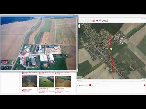
Geotagging is rather simple tool for manipulating with geographical information stored in JPEG images (in EXIF section). Your photos can be augmented by GPS coordinates by synchronization from track log files (*.gpx). The GPS coordinates can be also adjusted manually using Drag and Drop.

Installation

  • Windows - download exe file from releases section
  • Fedora - add COPR repository and install rpms
  • Other Linux distributions - use flatpak

Download on Flathub

Copr build status

Contribute

  • Translate to your language at transifex.
  • Feel free to open issue
  • Feel free to create merge request

Screenshots

screenshot screenshot2

Video tutorial

Click to play on youtube

www.fit.vutbr.cz/study/DP/BP.php.cs?id=11578

Note that the project description data, including the texts, logos, images, and/or trademarks, for each open source project belongs to its rightful owner. If you wish to add or remove any projects, please contact us at [email protected].