All Projects → der-stefan → Opentopomap

der-stefan / Opentopomap

Licence: other
A topographic map from OpenStreetMap and SRTM data

Programming Languages

javascript
184084 projects - #8 most used programming language

Projects that are alternatives of or similar to Opentopomap

osmoscope-ui
An OpenStreetMap Quality Assurance Tool - User Interface
Stars: ✭ 31 (-89.49%)
Mutual labels:  openstreetmap
dodgr
Distances on Directed Graphs in R
Stars: ✭ 106 (-64.07%)
Mutual labels:  openstreetmap
Hootenanny
Hootenanny conflates multiple maps into a single seamless map.
Stars: ✭ 264 (-10.51%)
Mutual labels:  openstreetmap
osm-analytics-cruncher
Backend code for osm-analytics
Stars: ✭ 14 (-95.25%)
Mutual labels:  openstreetmap
basemaps
Scripts to generate MapServer mapfiles based on OpenStreetMap data. Please submit pull requests to the 'main' branch.
Stars: ✭ 51 (-82.71%)
Mutual labels:  openstreetmap
Offroad-routing-engine
Off-road Navigation System
Stars: ✭ 16 (-94.58%)
Mutual labels:  openstreetmap
openinframap
Open Infrastructure Map
Stars: ✭ 59 (-80%)
Mutual labels:  openstreetmap
Josm
Mirror of @JOSM's Subversion repository
Stars: ✭ 282 (-4.41%)
Mutual labels:  openstreetmap
osm-teams
Teams for OpenStreetMap! Check the beta 👉
Stars: ✭ 14 (-95.25%)
Mutual labels:  openstreetmap
Openstreetmap Heatmap
Visualization of OpenStreetMap Data with Blender and Python
Stars: ✭ 261 (-11.53%)
Mutual labels:  openstreetmap
overpass-api-ruby
A Ruby wrapper for OpenStreetMap Overpass API
Stars: ✭ 22 (-92.54%)
Mutual labels:  openstreetmap
osm-tile-access-log-viewer
👀 Visualize tile logs from planet.osm.org/tile_logs
Stars: ✭ 16 (-94.58%)
Mutual labels:  openstreetmap
map-machine
Python renderer for OpenStreetMap with custom icons intended to display as many map features as possible
Stars: ✭ 82 (-72.2%)
Mutual labels:  openstreetmap
osm-wikidata
Match OSM entities with Wikidata items
Stars: ✭ 72 (-75.59%)
Mutual labels:  openstreetmap
Osmnx
OSMnx: Python for street networks. Retrieve, model, analyze, and visualize street networks and other spatial data from OpenStreetMap.
Stars: ✭ 3,357 (+1037.97%)
Mutual labels:  openstreetmap
bexhill-osm
A local mapping project using data from OpenStreetMap. Includes overlays, walking directions and historical information.
Stars: ✭ 16 (-94.58%)
Mutual labels:  openstreetmap
everystreet
An algorithm finding #everystreet route on Open Street Map (OSMnx)
Stars: ✭ 43 (-85.42%)
Mutual labels:  openstreetmap
Libosmium
Fast and flexible C++ library for working with OpenStreetMap data.
Stars: ✭ 286 (-3.05%)
Mutual labels:  openstreetmap
Tilemill
TileMill is a modern map design studio
Stars: ✭ 2,952 (+900.68%)
Mutual labels:  openstreetmap
is-osm-uptodate
Find outdated nodes in OpenStreetMap
Stars: ✭ 16 (-94.58%)
Mutual labels:  openstreetmap

OpenTopoMap

OpenTopoMap is a topographic map out of data from OpenStreetMap and SRTM. If you are interested in building your own OpenTopoMap, see the beginner's guides for a tile server and for Garmin files.

Mapnik

The main OpenTopoMap is a online rendered raster map. It can be used with the web interface on https://opentopomap.org, which gives you nice features like a search function or loading your gpx tracks. Futhermore, OpenTopoMap can be included into other applications. See https://opentopomap.org/about#verwendung for information on usage. The license of the online map is CC-BY-SA.

The online renderer is based on Mapnik. All necessary files are available to build your own OpenTopoMap server.

Garmin

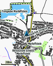
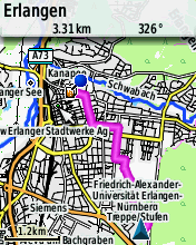
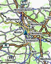
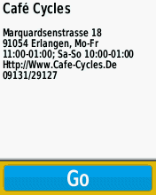
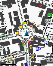
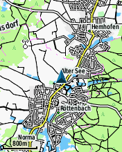
Since summer 2014 there is a Garmin edition of the OpenTopoMap. They can be downloaded from http://garmin.opentopomap.org. The license of the Garmin maps is CC-BY-NC-SA and therefore reselling is not allowed. Here are some screenshots:

screenshot1 screenshot2 screenshot3 screenshot4 screenshot5 screenshot6

Note that the project description data, including the texts, logos, images, and/or trademarks, for each open source project belongs to its rightful owner. If you wish to add or remove any projects, please contact us at [email protected].