
| Package | Description | Status |
|---|---|---|
| PyNHD | Navigate and subset NHDPlus (MR and HR) using web services | |
| Py3DEP | Access topographic data through National Map's 3DEP web service | |
| PyGeoHydro | Access NWIS, NID, WQP, HCDN 2009, NLCD, and SSEBop databases | |
| PyDaymet | Access Daymet for daily climate data both single pixel and gridded | |
| AsyncRetriever | High-level API for asynchronous requests with persistent caching | |
| PyGeoOGC | Send queries to any ArcGIS RESTful-, WMS-, and WFS-based services | |
| PyGeoUtils | Convert responses from PyGeoOGC's supported web services to datasets |
PyNHD: Navigate and subset NHDPlus database


Features
PyNHD is a part of HyRiver software stack that is designed to aid in watershed analysis through web services.
This package provides access to WaterData, the National Map's NHDPlus HR, NLDI, and PyGeoAPI web services. These web services can be used to navigate and extract vector data from NHDPlus V2 (both medium- and high-resolution) database such as catchments, HUC8, HUC12, GagesII, flowlines, and water bodies. Moreover, PyNHD gives access to an item on ScienceBase called Select Attributes for NHDPlus Version 2.1 Reach Catchments and Modified Network Routed Upstream Watersheds for the Conterminous United States. This item provides over 30 attributes at catchment-scale based on NHDPlus ComIDs. These attributes are available in three categories:
- Local (local): For individual reach catchments,
- Total (upstream_acc): For network-accumulated values using total cumulative drainage area,
- Divergence (div_routing): For network-accumulated values using divergence-routed.
Moreover, the PyGeoAPI service provides four functionalities:
flow_trace: Trace flow from a starting point to up/downstream direction.split_catchment: Split the local catchment of a point of interest at the point's location.elevation_profile: Extract elevation profile along a flow path between two points.cross_section: Extract cross-section at a point of interest along a flow line.
A list of these attributes for each characteristic type can be accessed using nhdplus_attrs
function.
Similarly, PyNHD uses this
item on Hydroshare to get ComID-linked NHDPlus Value Added Attributes. This dataset includes
slope and roughness, among other attributes, for all the flowlines. You can use nhdplus_vaa
function to get this dataset.
Additionally, PyNHD offers some extra utilities for processing the flowlines:
flowline_xsection: Get cross-section lines along a flowline at a given spacing.network_xsection: Get cross-section lines along a network of flowlines at a given spacing.prepare_nhdplus: For cleaning up the dataframe by, for example, removing tiny networks, adding ato_comidcolumn, and finding a terminal flowlines if it doesn't exist.topoogical_sort: For sorting the river network topologically which is useful for routing and flow accumulation.vector_accumulation: For computing flow accumulation in a river network. This function is generic, and any routing method can be plugged in.
These utilities are developed based on an R package called
nhdplusTools.
All functions and classes that request data from web services use async_retriever
that offers response caching. By default, the expiration time is set to never expire.
All these functions and classes have two optional parameters for controlling the cache:
expire_after and disable_caching. You can use expire_after to set the expiration
time in seconds. If expire_after is set to -1, the cache will never expire (default).
You can use disable_caching if you don't want to use the cached responses. The cached
responses are stored in the ./cache/aiohttp_cache.sqlite file.
You can find some example notebooks here.
Moreover, to fully utilize the capabilities of these web services, under-the-hood, PyNHD uses AsyncRetriever for retrieving topographic data asynchronously with persistent caching. This improves the reliability and speed of data retrieval significantly.
You can also try using PyNHD without installing it on your system by clicking on the binder badge. A Jupyter Lab instance with the HyRiver stack pre-installed will be launched in your web browser, and you can start coding!
Please note that since this project is in early development stages, while the provided functionalities should be stable, changes in APIs are possible in new releases. But we appreciate it if you give this project a try and provide feedback. Contributions are most welcome.
Moreover, requests for additional functionalities can be submitted via issue tracker.
Installation
You can install PyNHD using pip after installing libgdal on your system
(for example, in Ubuntu run sudo apt install libgdal-dev):
$ pip install pynhdAlternatively, PyNHD can be installed from the conda-forge repository
using Conda
or Mamba:
$ conda install -c conda-forge pynhdQuick start
Let's explore the capabilities of NLDI. We need to instantiate the class first:
from pynhd import NLDI, WaterData, NHDPlusHR
import pynhd as nhd
First, let's get the watershed geometry of the contributing basin of a
USGS station using NLDI:
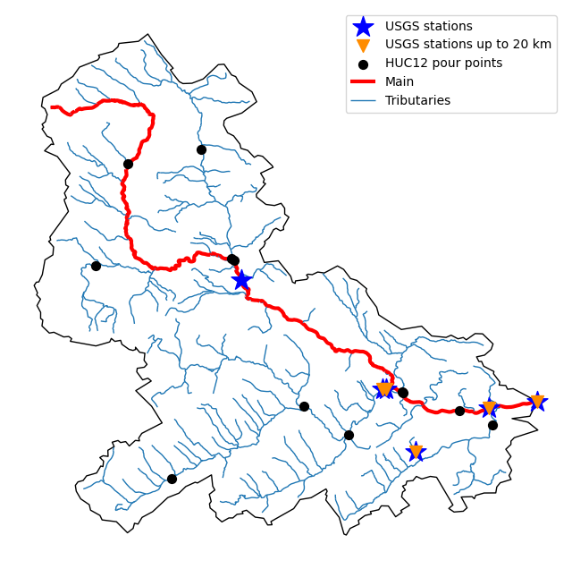
nldi = NLDI()
station_id = "01031500"

basin = nldi.get_basins(station_id)
The navigate_byid class method can be used to navigate NHDPlus in
both upstream and downstream of any point in the database. Let's get ComIDs and flowlines
of the tributaries and the main river channel in the upstream of the station.
flw_main = nldi.navigate_byid(
    fsource="nwissite",
    fid=f"USGS-{station_id}",
    navigation="upstreamMain",
    source="flowlines",
    distance=1000,
)

flw_trib = nldi.navigate_byid(
    fsource="nwissite",
    fid=f"USGS-{station_id}",
    navigation="upstreamTributaries",
    source="flowlines",
    distance=1000,
)
We can get other USGS stations upstream (or downstream) of the station and even set a distance limit (in km):
st_all = nldi.navigate_byid(
    fsource="nwissite",
    fid=f"USGS-{station_id}",
    navigation="upstreamTributaries",
    source="nwissite",
    distance=1000,
)

st_d20 = nldi.navigate_byid(
    fsource="nwissite",
    fid=f"USGS-{station_id}",
    navigation="upstreamTributaries",
    source="nwissite",
    distance=20,
)
Now, let's get the HUC12 pour points:
pp = nldi.navigate_byid(
    fsource="nwissite",
    fid=f"USGS-{station_id}",
    navigation="upstreamTributaries",
    source="huc12pp",
    distance=1000,
)
Also, we can get the slope data for each river segment from NHDPlus VAA database:
vaa = nhd.nhdplus_vaa("input_data/nhdplus_vaa.parquet")

flw_trib["comid"] = pd.to_numeric(flw_trib.nhdplus_comid)
slope = gpd.GeoDataFrame(
    pd.merge(flw_trib, vaa[["comid", "slope"]], left_on="comid", right_on="comid"),
    crs=flw_trib.crs,
)
slope[slope.slope < 0] = np.nan
Additionally, we can obtain cross-section lines along the main river channel with 4 km spacing
and width of 2 km using network_xsection as follows:
from pynhd import NHD

distance = 4000  # in meters
width = 2000  # in meters
nhd = NHD("flowline_mr")
main_nhd = nhd.byids("COMID", flw_main.index)
main_nhd = pynhd.prepare_nhdplus(main_nhd, 0, 0, 0, purge_non_dendritic=True)
main_nhd = main_nhd.to_crs("ESRI:102003")
cs = pynhd.network_xsection(main_nhd, distance, width)
Then, we can use Py3DEP to obtain the elevation profile along the cross-section lines.
Now, let's explore the PyGeoAPI capabilities:
pygeoapi = PyGeoAPI()

trace = pygeoapi.flow_trace(
    (1774209.63, 856381.68), crs="ESRI:102003", raindrop=False, direction="none"
)

split = pygeoapi.split_catchment((-73.82705, 43.29139), crs="epsg:4326", upstream=False)

profile = pygeoapi.elevation_profile(
    [(-103.801086, 40.26772), (-103.80097, 40.270568)], numpts=101, dem_res=1, crs="epsg:4326"
)

section = pygeoapi.cross_section((-103.80119, 40.2684), width=1000.0, numpts=101, crs="epsg:4326")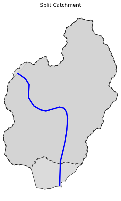
Next, we retrieve the medium- and high-resolution flowlines within the bounding box of our
watershed and compare them. Moreover, Since several web services offer access to NHDPlus database,
NHDPlusHR has an argument for selecting a service and also an argument for automatically
switching between services.
mr = WaterData("nhdflowline_network")
nhdp_mr = mr.bybox(basin.geometry[0].bounds)

hr = NHDPlusHR("networknhdflowline", service="hydro", auto_switch=True)
nhdp_hr = hr.bygeom(basin.geometry[0].bounds)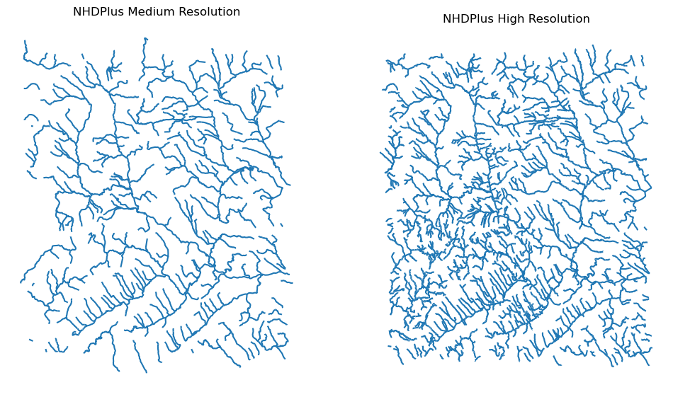
Moreover, WaterData can find features within a given radius (in meters) of a point:
eck4 = "+proj=eck4 +lon_0=0 +x_0=0 +y_0=0 +datum=WGS84 +units=m +no_defs"
coords = (-5727797.427596455, 5584066.49330473)
rad = 5e3
flw_rad = mr.bydistance(coords, rad, loc_crs=eck4)
flw_rad = flw_rad.to_crs(eck4)
Instead of getting all features within a radius of the coordinate, we can snap to the closest flowline using NLDI:
comid_closest = nldi.comid_byloc((x, y), eck4)
flw_closest = nhdp_mr.byid("comid", comid_closest.comid.values[0])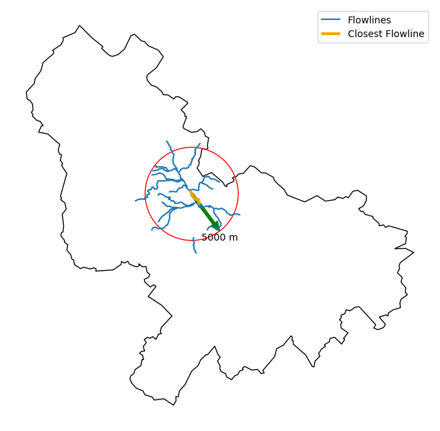
Since NHDPlus HR is still at the pre-release stage let's use the MR flowlines to
demonstrate the vector-based accumulation.
Based on a topological sorted river network
pynhd.vector_accumulation computes flow accumulation in the network.
It returns a dataframe which is sorted from upstream to downstream that
shows the accumulated flow in each node.
PyNHD has a utility called prepare_nhdplus that identifies such
relationship among other things such as fixing some common issues with
NHDPlus flowlines. But first we need to get all the NHDPlus attributes
for each ComID since NLDI only provides the flowlines' geometries
and ComIDs which is useful for navigating the vector river network data.
For getting the NHDPlus database we use WaterData. Let's use the
nhdflowline_network layer to get required info.
wd = WaterData("nhdflowline_network")

comids = flw_trib.nhdplus_comid.to_list()
nhdp_trib = wd.byid("comid", comids)
flw = nhd.prepare_nhdplus(nhdp_trib, 0, 0, purge_non_dendritic=False)
To demonstrate the use of routing, let's use nhdplus_attrs function to get list of available
NHDPlus attributes
char = "CAT_RECHG"
area = "areasqkm"

local = nldi.getcharacteristic_byid(comids, "local", char_ids=char)
flw = flw.merge(local[char], left_on="comid", right_index=True)


def runoff_acc(qin, q, a):
    return qin + q * a


flw_r = flw[["comid", "tocomid", char, area]]
runoff = nhd.vector_accumulation(flw_r, runoff_acc, char, [char, area])


def area_acc(ain, a):
    return ain + a


flw_a = flw[["comid", "tocomid", area]]
areasqkm = nhd.vector_accumulation(flw_a, area_acc, area, [area])

runoff /= areasqkm
Since these are catchment-scale characteristic, let's get the catchments then add the accumulated characteristic as a new column and plot the results.
wd = WaterData("catchmentsp")
catchments = wd.byid("featureid", comids)

c_local = catchments.merge(local, left_on="featureid", right_index=True)
c_acc = catchments.merge(runoff, left_on="featureid", right_index=True)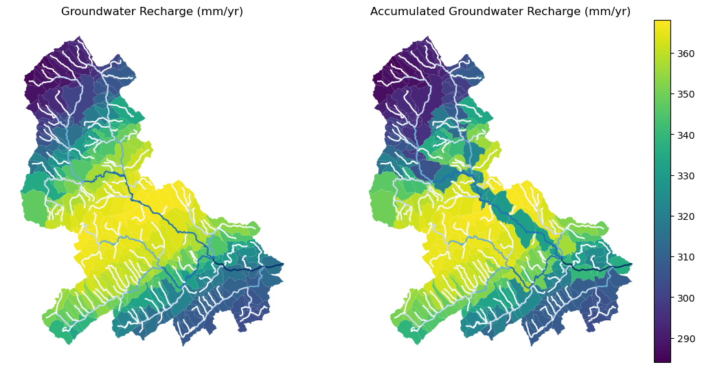
More examples can be found here.
Contributing
Contributions are very welcomed. Please read CONTRIBUTING.rst file for instructions.