All Projects → melissa135 → deep_typhoon

melissa135 / deep_typhoon

Licence: other
Analysis satellite images of typhoons in deep-learning (CNN).

Programming Languages

python
139335 projects - #7 most used programming language

Projects that are alternatives of or similar to deep typhoon

goes2go
Download and process GOES-16 and GOES-17 data from NOAA's archive on AWS using Python.
Stars: ✭ 77 (+196.15%)
Mutual labels:  satellite-imagery
georaster-layer-for-leaflet
Display GeoTIFFs and soon other types of raster on your Leaflet Map
Stars: ✭ 168 (+546.15%)
Mutual labels:  satellite-imagery
Julia Geospatial
Examples for a blog series on Geospatial Julia using ArchGDAL
Stars: ✭ 58 (+123.08%)
Mutual labels:  satellite-imagery
eemont
A python package that extends Google Earth Engine.
Stars: ✭ 290 (+1015.38%)
Mutual labels:  satellite-imagery
community-sprints
This repo is used to organize and collaborate in sprints for code projects, hackathons, STAC and metadata specs development
Stars: ✭ 18 (-30.77%)
Mutual labels:  satellite-imagery
pixel-decoder
A tool for running deep learning algorithms for semantic segmentation with satellite imagery
Stars: ✭ 68 (+161.54%)
Mutual labels:  satellite-imagery
xarray-sentinel
Xarray backend to Copernicus Sentinel-1 satellite data products
Stars: ✭ 189 (+626.92%)
Mutual labels:  satellite-imagery
spyndex
Awesome Spectral Indices in Python.
Stars: ✭ 56 (+115.38%)
Mutual labels:  satellite-imagery
Start maja
To process a Sentinel-2 time series with MAJA cloud detection and atmospheric correction processor
Stars: ✭ 47 (+80.77%)
Mutual labels:  satellite-imagery
fabric
Urban change model designed to identify changes across 2 timestamps
Stars: ✭ 53 (+103.85%)
Mutual labels:  satellite-imagery
lightweight-temporal-attention-pytorch
A PyTorch implementation of the Light Temporal Attention Encoder (L-TAE) for satellite image time series. classification
Stars: ✭ 43 (+65.38%)
Mutual labels:  satellite-imagery
earthacrosstime
Twitter bot that posts videos showcasing how random locations in the world have changed since 1984.
Stars: ✭ 28 (+7.69%)
Mutual labels:  satellite-imagery
awesome-spectral-indices
A ready-to-use curated list of Spectral Indices for Remote Sensing applications.
Stars: ✭ 357 (+1273.08%)
Mutual labels:  satellite-imagery
GoogleEarthEngine-side-projects
Google Earth Engine side projects and tutorial scripts
Stars: ✭ 23 (-11.54%)
Mutual labels:  satellite-imagery
kaggle-satellite-imagery-feature-detection
Satellite Imagery Feature Detection (68 out of 419)
Stars: ✭ 29 (+11.54%)
Mutual labels:  satellite-imagery
sentinel-util
A CLI for downloading, processing, and making a mosaic from Sentinel-1, -2 and -3 data
Stars: ✭ 22 (-15.38%)
Mutual labels:  satellite-imagery
eodag
Earth Observation Data Access Gateway
Stars: ✭ 183 (+603.85%)
Mutual labels:  satellite-imagery
Danesfield
Kitware's system for 3D building reconstruction for the IARPA CORE3D program
Stars: ✭ 100 (+284.62%)
Mutual labels:  satellite-imagery
U-Net-Satellite
Road Detection from satellite images using U-Net.
Stars: ✭ 38 (+46.15%)
Mutual labels:  satellite-imagery
ee extra
A ninja python package that unifies the Google Earth Engine ecosystem.
Stars: ✭ 42 (+61.54%)
Mutual labels:  satellite-imagery

deep_typhoon

Analysis satellite images of typhoons by deep-learning (CNN), based on PyTorch.

This CNN learns to map the satellite images of typhoons to their max wind speed from. The labeled train set is obtained from agora/JMA.

Online analysis: http://www.predictor.xin/typhoon/

Requirements

  • BeautifulSoup
  • PIL
  • Pytorch

Usage

  1. Run download_agora.py, download the satellite images of typhoons to folder tys_raw.
  2. Run create_samples.py, convert raw data into the legal samples for our CNN, create two new forlder train_set and test_set.
  3. Train CNN using train_net.py, the trained CNN will be saved as a disk file net_relu.pth.
  4. Run test_net.py, analysis the test set.

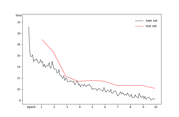
After 10 epoches training the CNN regressor reached mean loss about 8 (knots) in train set and about 10 (knots) in test set.

Here is what this CNN thinks of the top 20 typhoons sorted by max wind.

1 ('197920', 130.27679443359375)  
2 ('200914', 127.7662582397461)  
3 ('199019', 122.92172241210938)  
4 ('200918', 122.84004211425781)  
5 ('201614', 122.66597747802734)  
6 ('201601', 122.03250885009766)  
7 ('201513', 121.75947570800781)  
8 ('200922', 121.35771942138672)  
9 ('201013', 120.0194091796875)  
10 ('201330', 118.92587280273438)  
11 ('201419', 117.6025390625)  
12 ('198305', 117.10270690917969)  
13 ('201422', 116.77259063720703)  
14 ('198522', 116.46116638183594)  
15 ('201327', 116.42304992675781)  
16 ('201216', 116.36921691894531)  
17 ('198221', 116.18096923828125)  
18 ('199230', 115.96656799316406)  
19 ('198210', 115.96611022949219)  
20 ('201328', 115.57132720947266)  

Tips

  • Memory should be at least 1.5G .
  • This project is written without cuda(), while you can use cuda() to transfer the CNN onto GPU and speedup the training.
  • The images and labels are crawled from agora.ax.nii.ac.jp/digital-typhoon , and the labels are refered to JMA(Japan Meteorological agency).

More Information

See https://mp.weixin.qq.com/s/PBm6sre7u3pEbx_aqjZLwA

Note that the project description data, including the texts, logos, images, and/or trademarks, for each open source project belongs to its rightful owner. If you wish to add or remove any projects, please contact us at [email protected].