All Projects → aaronboda24 → Loose Gnss Imu

aaronboda24 / Loose Gnss Imu

Licence: mit
Loosely coupled integration of GNSS and IMU

Projects that are alternatives of or similar to Loose Gnss Imu

ESP32 IMU BARO GPS VARIO
GPS altimeter/variometer with LCD display, routes with waypoints, data/gps track logging, bluetooth NMEA sentence transmission, wifi AP + webpage configuration
Stars: ✭ 72 (-25.77%)
Mutual labels:  gps, imu, kalman-filter
Staticmapping
Use LiDAR to map the static world
Stars: ✭ 191 (+96.91%)
Mutual labels:  gps, imu
Venom
All Terrain Autonomous Quadruped
Stars: ✭ 145 (+49.48%)
Mutual labels:  imu, kalman-filter
Map Based Visual Localization
A general framework for map-based visual localization. It contains 1) Map Generation which support traditional features or deeplearning features. 2) Hierarchical-Localizationvisual in visual(points or line) map. 3)Fusion framework with IMU, wheel odom and GPS sensors.
Stars: ✭ 229 (+136.08%)
Mutual labels:  gps, imu
Eskf
ROS Error-State Kalman Filter based on PX4/ecl. Performs GPS/Magnetometer/Vision Pose/Optical Flow/RangeFinder fusion with IMU
Stars: ✭ 63 (-35.05%)
Mutual labels:  gps, imu
Location
Smartphone navigation positionning, fusion GPS and IMU sensors.
Stars: ✭ 87 (-10.31%)
Mutual labels:  gps, imu
Embedded UKF Library
A compact Unscented Kalman Filter (UKF) library for Teensy4/Arduino system (or any real time embedded system in general)
Stars: ✭ 31 (-68.04%)
Mutual labels:  imu, kalman-filter
Freeimu Updates
IMU - FreeIMU Library Zero Drift, Altitude & LSM303 Heading Stability
Stars: ✭ 267 (+175.26%)
Mutual labels:  imu, kalman-filter
ios logger
Application for camera and sensor data logging (iOS)
Stars: ✭ 60 (-38.14%)
Mutual labels:  gps, imu
imusensor
Python library for communication between raspberry pi and MPU9250 imu
Stars: ✭ 47 (-51.55%)
Mutual labels:  imu, kalman-filter
Multi sensor fusion
Multi-Sensor Fusion (GNSS, IMU, Camera) 多源多传感器融合定位 GPS/INS组合导航 PPP/INS紧组合
Stars: ✭ 357 (+268.04%)
Mutual labels:  gps, imu
Navego
NaveGo: an open-source MATLAB/GNU Octave toolbox for processing integrated navigation systems and performing inertial sensors analysis.
Stars: ✭ 294 (+203.09%)
Mutual labels:  gps, imu
Gnss Ins Sim
Open-source GNSS + inertial navigation, sensor fusion simulator. Motion trajectory generator, sensor models, and navigation
Stars: ✭ 422 (+335.05%)
Mutual labels:  gps, imu
Micronmea
A compact Arduino library to parse NMEA sentences.
Stars: ✭ 66 (-31.96%)
Mutual labels:  gps
Lego Loam
LeGO-LOAM: Lightweight and Ground-Optimized Lidar Odometry and Mapping on Variable Terrain
Stars: ✭ 1,138 (+1073.2%)
Mutual labels:  imu
Geogeometry
GeoGeometry is a set of algorithms and functions for manipulating geo hashes and geometric shapes with geo coordinates.
Stars: ✭ 94 (-3.09%)
Mutual labels:  gps
Urbannavdataset
UrbanNav: an Open-Sourcing Localization Data Collected in Asian Urban Canyons, Including Tokyo and Hong Kong
Stars: ✭ 79 (-18.56%)
Mutual labels:  imu
Aprs
Python APRS Module
Stars: ✭ 62 (-36.08%)
Mutual labels:  gps
Find Maraudersmap
Internal positioning for everyone, in the style of Harry Potter
Stars: ✭ 62 (-36.08%)
Mutual labels:  gps
Gpx Simplify Optimizer
Free Tracks Optimizer Online Service
Stars: ✭ 61 (-37.11%)
Mutual labels:  gps

Loose-GNSS-IMU

Loose-coupling is the most commonly used method for integrating GNSS-IMU due to its efficiency and simplicity. The idea is to treat the two sensors completely independent of each other. For the inertial sensor, the summation of acceleration and angular rate over time is used to produce position, velocity and attitude solutions (aka. mechanization). Concurrently, the GNSS sensor also generates position and velocity solutions, albeit at a slower rate than the inertial sensor. Both solutions are then combined at specific intervals using a Kalman filter in order to estimate the error states of the inertial sensor like biases or scale factors. These error estimates are used in a recursive manner to improve the accuracy of the inertial navigation solution.

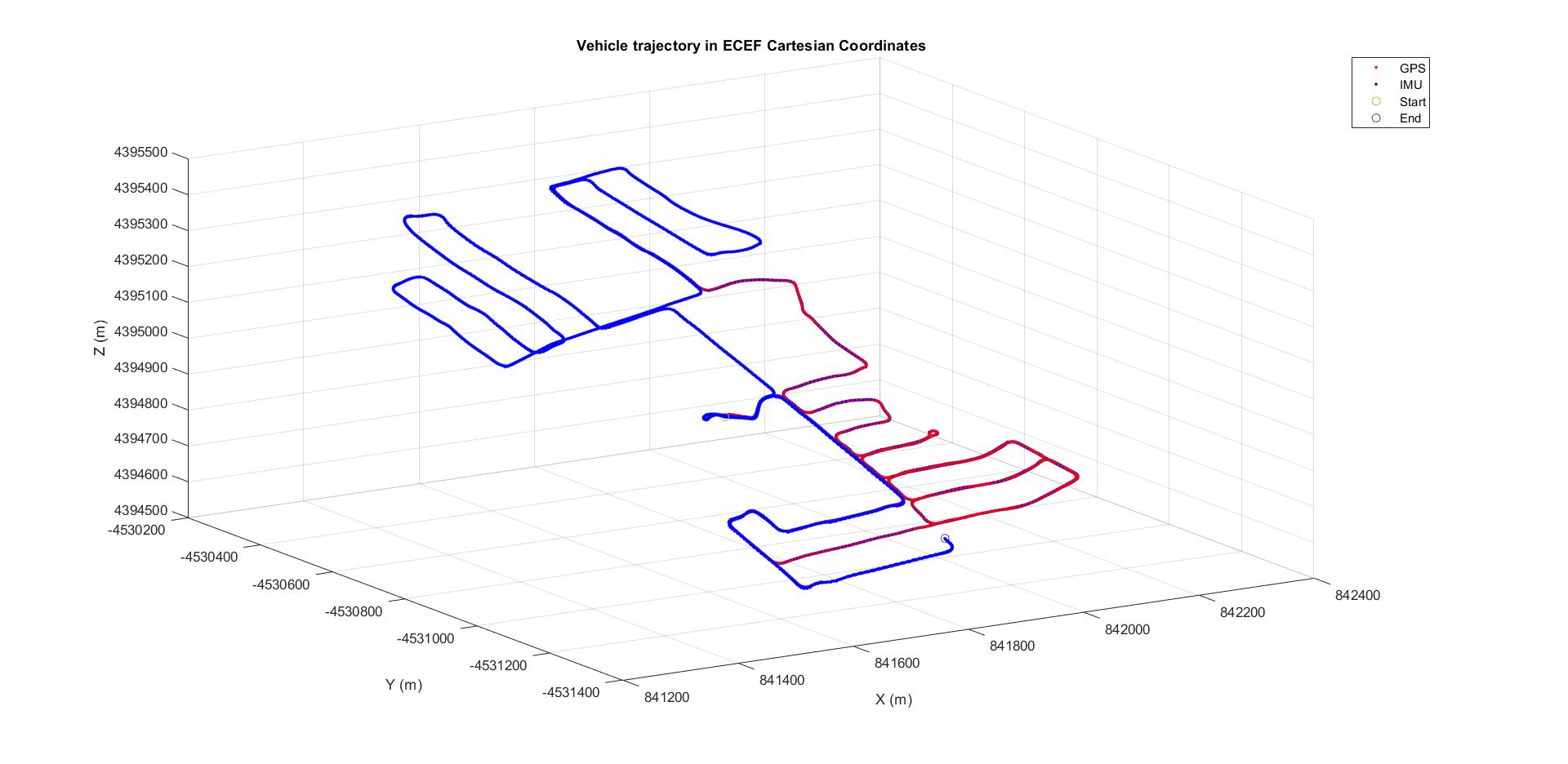
The IMU mechanization is performed in ECEF Cartesian coordinates as described in the Paul Groves textbook : Principles of GNSS, Inertial, and Multisensor Integrated Navigation Systems, 2nd Edition.

Installation

You need Eigen 3.3.7 and Visual Studio 2017. I have included eigen here along with relative path property so that you can simply download the project and open "Loose-GNSS-IMU.sln". You can find more info about using eigen with VS here.

Testing

You will find instructions in "Loose-GNSS-IMU.cpp" where you need to set the path of the input files, but pay attention to the file format. You can find input file samples in the "Input" folder. Simply recreate your input to accommodate the format supported by the reader provided in this program.

Results

ECEF Solution 2-D Solution in LLF
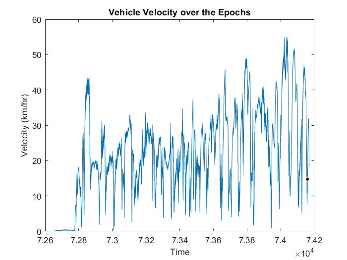
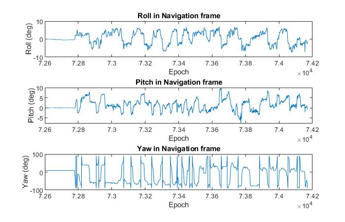
Vehicle Velocity Attitude

License

Free-to-use (MIT), but at your own risk. Credits to Eigen Library.

Note that the project description data, including the texts, logos, images, and/or trademarks, for each open source project belongs to its rightful owner. If you wish to add or remove any projects, please contact us at [email protected].