All Projects → tgrippa → Opensource_OBIA_processing_chain

tgrippa / Opensource_OBIA_processing_chain

Licence: MIT license
An open-source semi-automated processing chain for urban OBIA classification.

Programming Languages

Jupyter Notebook
11667 projects

Projects that are alternatives of or similar to Opensource OBIA processing chain

Deep Learning For Image Processing
deep learning for image processing including classification and object-detection etc.
Stars: ✭ 5,808 (+7644%)
Mutual labels:  classification, segmentation
Geospatial Machine Learning
A curated list of resources focused on Machine Learning in Geospatial Data Science.
Stars: ✭ 289 (+285.33%)
Mutual labels:  remote-sensing, classification
Imgclsmob
Sandbox for training deep learning networks
Stars: ✭ 2,405 (+3106.67%)
Mutual labels:  classification, segmentation
Pointasnl
PointASNL: Robust Point Clouds Processing using Nonlocal Neural Networks with Adaptive Sampling (CVPR 2020)
Stars: ✭ 159 (+112%)
Mutual labels:  classification, segmentation
ChangeOS
ChangeOS: Building damage assessment via Deep Object-based Semantic Change Detection - (RSE 2021)
Stars: ✭ 33 (-56%)
Mutual labels:  remote-sensing, object-based-image-analysis
Pointnet2
PointNet++: Deep Hierarchical Feature Learning on Point Sets in a Metric Space
Stars: ✭ 2,197 (+2829.33%)
Mutual labels:  classification, segmentation
Torchsat
🔥TorchSat 🌏 is an open-source deep learning framework for satellite imagery analysis based on PyTorch.
Stars: ✭ 261 (+248%)
Mutual labels:  remote-sensing, classification
Paddlex
PaddlePaddle End-to-End Development Toolkit(『飞桨』深度学习全流程开发工具)
Stars: ✭ 3,399 (+4432%)
Mutual labels:  classification, segmentation
Skin-Cancer-Segmentation
Classification and Segmentation with Mask-RCNN of Skin Cancer using ISIC dataset
Stars: ✭ 61 (-18.67%)
Mutual labels:  classification, segmentation
Awesome-Tensorflow2
基于Tensorflow2开发的优秀扩展包及项目
Stars: ✭ 45 (-40%)
Mutual labels:  classification, segmentation
Dgcnn.pytorch
A PyTorch implementation of Dynamic Graph CNN for Learning on Point Clouds (DGCNN)
Stars: ✭ 153 (+104%)
Mutual labels:  classification, segmentation
mmrazor
OpenMMLab Model Compression Toolbox and Benchmark.
Stars: ✭ 644 (+758.67%)
Mutual labels:  classification, segmentation
Sunets
PyTorch Implementation of Stacked U-Nets (SUNets)
Stars: ✭ 149 (+98.67%)
Mutual labels:  classification, segmentation
HRFormer
This is an official implementation of our NeurIPS 2021 paper "HRFormer: High-Resolution Transformer for Dense Prediction".
Stars: ✭ 357 (+376%)
Mutual labels:  classification, segmentation
Grid Gcn
Grid-GCN for Fast and Scalable Point Cloud Learning
Stars: ✭ 143 (+90.67%)
Mutual labels:  classification, segmentation
3d Pointcloud
Papers and Datasets about Point Cloud.
Stars: ✭ 179 (+138.67%)
Mutual labels:  classification, segmentation
Model Quantization
Collections of model quantization algorithms
Stars: ✭ 118 (+57.33%)
Mutual labels:  classification, segmentation
Vision4j Collection
Collection of computer vision models, ready to be included in a JVM project
Stars: ✭ 132 (+76%)
Mutual labels:  classification, segmentation
Raster Vision
An open source framework for deep learning on satellite and aerial imagery.
Stars: ✭ 1,248 (+1564%)
Mutual labels:  remote-sensing, classification
Point2Sequence
Point2Sequence: Learning the Shape Representation of 3D Point Clouds with an Attention-based Sequence to Sequence Network
Stars: ✭ 34 (-54.67%)
Mutual labels:  classification, segmentation

AN OPEN-SOURCE SEMI-AUTOMATED PROCESSING CHAIN FOR URBAN OBIA CLASSIFICATION

You will find on this repository the jupyter notebook of the processing chain developed with the open-source software GRASS GIS.

alt tag

Reference article in MDPI Remote Sensing journal

Remote Sensing special issue

More recent developments are available here: The processing chain presented in this repository was published in 2017 but evolved since throught more advanced segmentation optimization strategy (called SPUSPO [1][2]) that allow for unsupervised optimization on mutliple partitions of the scene (local approach instead of global approach implemented here [3]).

Keywords

  • Remote Sensing
  • Object Based Image Analysis
  • Urban Area
  • Land cover mapping
  • Supervised classification
  • Segmentation
  • Optimization
  • GRASS GIS

Abstract

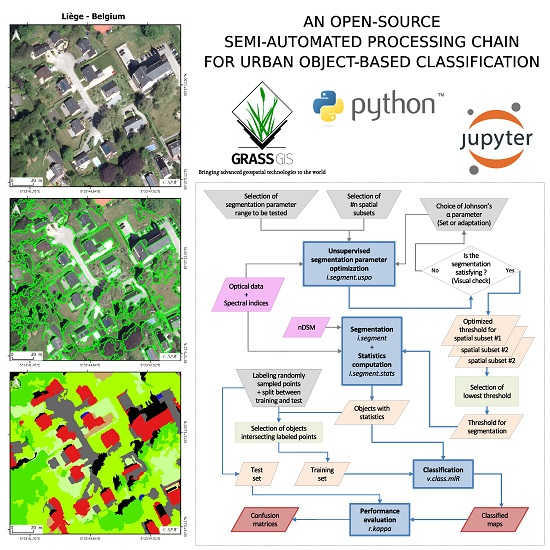
This study presents the development of a semi-automated processing chain for urban object-based land-cover and land-use classification. The processing chain is implemented in Python and relies on existing open-source software GRASS GIS and R. The complete tool chain is available in open access and is adaptable to specific user needs. For automation purposes, we developed two GRASS GIS add-ons enabling users (1) to optimize segmentation parameters in an unsupervised manner and (2) to classify remote sensing data using several individual machine learning classifiers or their prediction combinations through voting-schemes. We tested the performance of the processing chain using sub-metric multispectral and height data on two very different urban environments: Ouagadougou, Burkina Faso in sub-Saharan Africa and Liège, Belgium in Western Europe. Using a hierarchical classification scheme, the overall accuracy reached 93% at the first level (5 classes) and about 80% at the second level (11 and 9 classes, respectively).

Acknowledgments

This work was funded by the Belgian Federal Science Policy Office (BELSPO) (Research Program for Earth Observation STEREO III, contract SR/00/304 - as part of the MAUPP project and by Moerman research program of ISSeP SmartPop project.

Cite this code

Please use the following DOI for citing this code DOI

Recent developments

The processing chain evolved throught more advanced segmentation optimization strategy (called SPUSPO [1][2]) that allow for unsupervised optimization on mutliple partitions of the scene (local approach instead of global approach implemented here [3]). The most recent version of our processing chain is available here: https://github.com/tgrippa/Semi_automated_OBIA_processing_with_local_USPO

[1] Georganos, Stefanos, Tais Grippa, Moritz Lennert, Sabine Vanhuysse, Brian Johnson, and Eléonore Wolff. “Scale Matters: Spatially Partitioned Unsupervised Segmentation Parameter Optimization for Large and Heterogeneous Satellite Images.” Remote Sensing 10, no. 9 (September 9, 2018): 1440. https://doi.org/10.3390/rs10091440.

[2] Georganos, Stefanos, Taïs Grippa, Moritz Lennert, Sabine Vanhuysse, and Eleonore Wolff. “SPUSPO: Spatially Partitioned Unsupervised Segmentation Parameter Optimization for Efficiently Segmenting Large Heterogeneous Areas.” In Proceedings of the 2017 Conference on Big Data from Space (BiDS’17), 2017. https://goo.gl/yRBwPQ.

[3] Grippa, Tais, Stefanos Georganos, Sabine Vanhuysse, Moritz Lennert, and Eléonore Wolff. “A Local Segmentation Parameter Optimization Approach for Mapping Heterogeneous Urban Environments Using VHR Imagery.” In Proceedings Volume 10431, Remote Sensing Technologies and Applications in Urban Environments II. IEEE, 2017. https://doi.org/10.1117/12.2278422.

Note that the project description data, including the texts, logos, images, and/or trademarks, for each open source project belongs to its rightful owner. If you wish to add or remove any projects, please contact us at [email protected].