Esri / Arcgis Runtime Samples Ios
Programming Languages
Projects that are alternatives of or similar to Arcgis Runtime Samples Ios
ArcGIS Runtime SDK for iOS Samples 
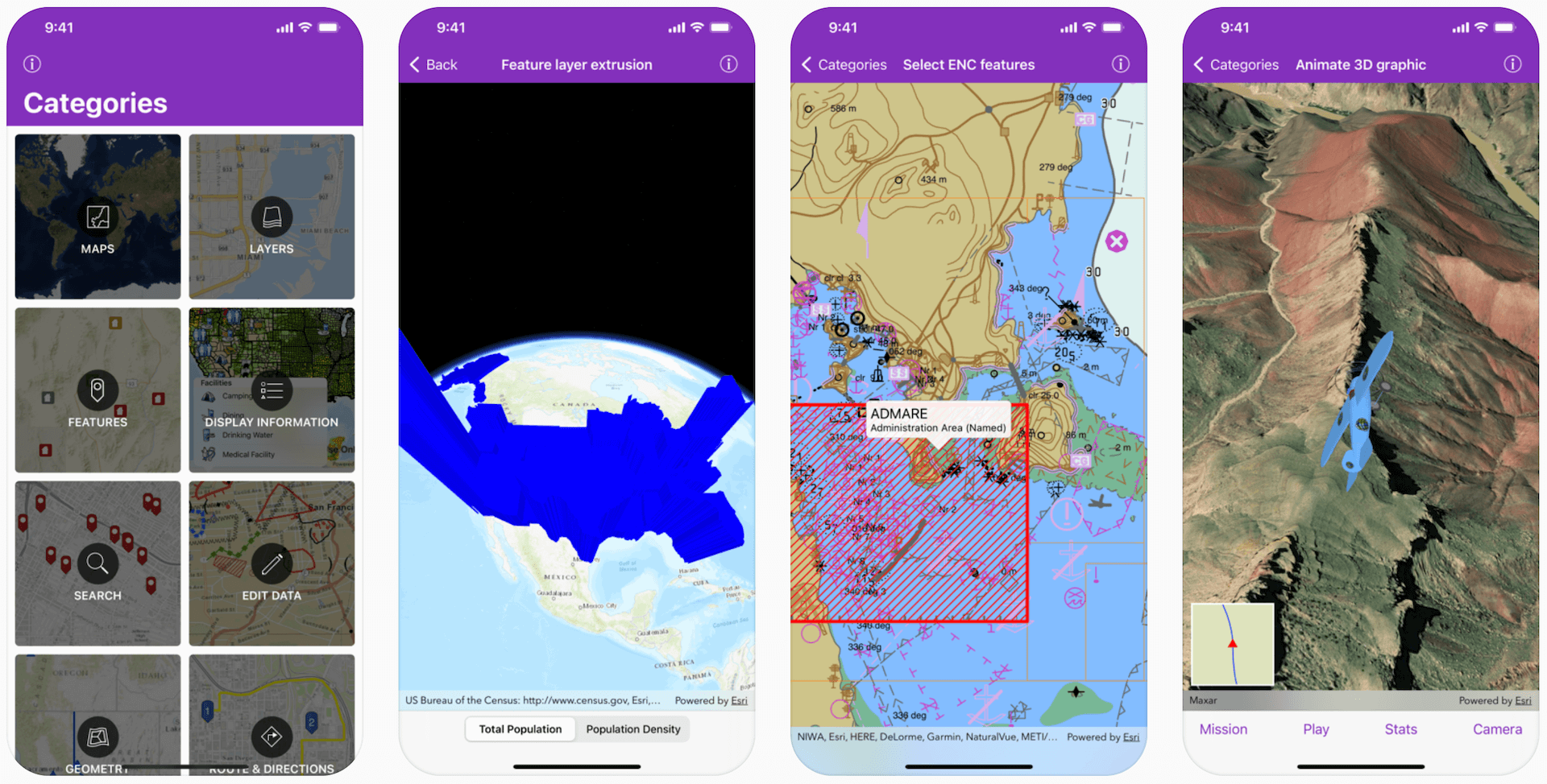
This repository contains Swift sample code demonstrating the capabilities of ArcGIS Runtime SDK for iOS and how to use them in your own app. The project can be opened in Xcode and run on a simulator or a device. Or you can download the app from the App Store on your iOS device.
The master branch of this repository contains samples configured for the latest available version of ArcGIS Runtime SDK for iOS. For samples configured for older versions of the SDK, look under the Releases tab for a specific version.
Features
- Maps - Open, create, interact with and save maps
- Layers - Display vector and raster data in maps and scenes
- Features - Work with feature layers and geodatabases
- Display Information - Show graphics, popups, callouts, and sketches
- Search - Find addresses, places, and points of interest
- Edit Data - Add, delete, and edit features and attachments
- Geometry - Create geometries and perform geometric operations
- Route & Directions - Calculate routes between locations and around barriers
- Analysis - Perform spatial analysis via geoprocessing tasks and services
- Cloud & Portal - Search for webmaps and list portal group users
- Scenes - Visualize 3D environments and symbols
- Utility Network - Work with utility networks, performing traces and exploring network elements
- Augmented Reality - View data overlaid on the real world through your device's camera
Requirements
- ArcGIS Runtime SDK for iOS 100.10.0 (or newer)
- ArcGIS Runtime Toolkit for iOS 100.10.0 (or newer)
- Xcode 12.0 (or newer)
The ArcGIS Runtime SDK Samples app has a Target SDK version of 12.0, meaning that it can run on devices with iOS 12.0 or newer.
Building samples using installed SDK
-
Fork and then clone the repository
Make sure to use the "recursive" option to ensure you get the ArcGIS Runtime Toolkit submodule
git clone --recursive [URL to Git repo]If you've already cloned the repo without the submodule, you can load the submodule using
git submodule update --init - Install the ArcGIS Runtime SDK for iOS to a central location on your Mac as described here
-
Open the
arcgis-ios-sdk-samples.xcodeprojproject file -
Run the
arcgis-ios-sdk-samplesapp targetIf you get the error message saying "This Copy Files build phase contains a reference to a missing file 'ArcGISToolkit.framework'", you probably didn't clone the repo to include it's submodule. See Step 1 above.
Building samples with CocoaPods
- Fork and then clone the repository
-
Install the ArcGIS Runtime SDK for iOS by running the
pod installcommand in the folder where you cloned this repository -
Open the
arcgis-ios-sdk-samples.xcworkspaceworkspace file -
Select the
arcgis-ios-sdk-samplesproject node, go to theBuild Phasestab, and delete the phases forEmbed Frameworks. (This phase conflicts with CocoaPods and is only required when using the installed SDK as described in the previous section) -
Select the
ArcGISToolkit.xcodeprojproject node and delete it. (this project dependency conflicts with CocoaPods and is only required when using the installed SDK as described in the previous section) -
Run the
arcgis-ios-sdk-samplesapp target
Sample Data
Some sample data is too large to store in the repository, so it is automatically downloaded at build time. The first time the app is built, a build script downloads the necessary data to Portal Data. The script only downloads data files that do not already exist, so subsequent builds will take significantly less time.
Configure app secrets
As a best-practices principle, the project conceals app secrets from source code by generating and compiling an AppSecrets.swift source code file at build time using a custom build rule.
This build rule looks for a secrets file stored in the project's root directory, $(SRCROOT)/.secrets.
Note: Without licensing or licensing with invalid keys do not throw an exception, but simply fail to license the app, falling back to Developer Mode (which will display a watermark on the map and scene views).
- Create a hidden secrets file in the project's root directory.
touch .secrets
- Add your License Key to the secrets file. Licensing the app will remove the 'Licensed for Developer Use Only' watermark. Licensing the app is optional in development but required for production. Optionally add your Extension License Key and API Key to the secrets file if needed. Acquire license keys from your dashboard.
echo ARCGIS_LICENSE_KEY=your-license-key >> .secrets
echo ARCGIS_EXTENSION_LICENSE_KEY=your-extension-license-key >> .secrets
echo ARCGIS_API_KEY=your-api-key >> .secrets
Replace 'your-license-key', 'your-extension-license-key' and 'your-api-key' with your keys.
- Uncomment the line
application.license()inAppDelegate.application(_:didFinishLaunchingWithOptions:), and choose the appropriate licensing method for your keys.
Visit the developer's website to learn more about Licensing your ArcGIS Runtime App and Security and authentication.
To learn more about masquerade, consult the documentation of Esri's Data Collection app.
Additional Resources
- Want to start a new project? Setup your dev environment
- New to the API? Explore the documentation : Guide | API Reference
- Got a question? Ask the community on our forum
Issues
Find a bug or want to request a new feature? Please let us know by submitting an issue.
Contributing
Esri welcomes contributions from anyone and everyone. Please see our guidelines for contributing.
Licensing
Copyright 2021 Esri
Licensed under the Apache License, Version 2.0 (the "License"); you may not use this file except in compliance with the License. You may obtain a copy of the License at
http://www.apache.org/licenses/LICENSE-2.0
Unless required by applicable law or agreed to in writing, software distributed under the License is distributed on an "AS IS" BASIS, WITHOUT WARRANTIES OR CONDITIONS OF ANY KIND, either express or implied. See the License for the specific language governing permissions and limitations under the License.
A copy of the license is available in the repository's LICENSE file.

