giswqs / Wetland Hydro Gee
Mapping wetland hydrological dynamics using Google Earth Engine (GEE)
Stars: ✭ 20
Programming Languages
javascript
184084 projects - #8 most used programming language
Labels
Projects that are alternatives of or similar to Wetland Hydro Gee
Whitebox Python
WhiteboxTools Python Frontend
Stars: ✭ 188 (+840%)
Mutual labels: lidar, remote-sensing, gis
Lidar
A Python package for delineating nested surface depressions from digital elevation data.
Stars: ✭ 85 (+325%)
Mutual labels: lidar, remote-sensing, gis
whiteboxgui
An interactive GUI for WhiteboxTools in a Jupyter-based environment
Stars: ✭ 94 (+370%)
Mutual labels: gis, remote-sensing, lidar
WhiteboxTools-ArcGIS
ArcGIS Python Toolbox for WhiteboxTools
Stars: ✭ 190 (+850%)
Mutual labels: gis, remote-sensing, lidar
pylandsat
Search, download, and preprocess Landsat imagery 🛰️
Stars: ✭ 49 (+145%)
Mutual labels: gis, remote-sensing
ee extra
A ninja python package that unifies the Google Earth Engine ecosystem.
Stars: ✭ 42 (+110%)
Mutual labels: gis, remote-sensing
spectral
Awesome Spectral Indices for the Google Earth Engine JavaScript API (Code Editor).
Stars: ✭ 68 (+240%)
Mutual labels: gis, remote-sensing
NodeMICMAC
A Lightweight REST API to Access MICMAC Photogrammetry and SFM Engine.
Stars: ✭ 54 (+170%)
Mutual labels: gis, remote-sensing
wildfire-forecasting
Forecasting wildfire danger using deep learning.
Stars: ✭ 39 (+95%)
Mutual labels: gis, remote-sensing
land-cover-to-land-use-classification
Satellite image processing pipeline to classify land-cover and land-use
Stars: ✭ 64 (+220%)
Mutual labels: gis, remote-sensing
geoblaze
Blazing Fast JavaScript Raster Processing Engine
Stars: ✭ 80 (+300%)
Mutual labels: gis, remote-sensing
awesome-spectral-indices
A ready-to-use curated list of Spectral Indices for Remote Sensing applications.
Stars: ✭ 357 (+1685%)
Mutual labels: gis, remote-sensing
Earthengine Py Notebooks
A collection of 360+ Jupyter Python notebook examples for using Google Earth Engine with interactive mapping
Stars: ✭ 807 (+3935%)
Mutual labels: remote-sensing, gis
earthengine-py-examples
A collection of 300+ examples for using Earth Engine and the geemap Python package
Stars: ✭ 76 (+280%)
Mutual labels: gis, remote-sensing
open-impact
To help quickstart impact work with Satellogic [hyperspectral] data
Stars: ✭ 21 (+5%)
Mutual labels: gis, remote-sensing
Datacube Core
Open Data Cube analyses continental scale Earth Observation data through time
Stars: ✭ 285 (+1325%)
Mutual labels: remote-sensing, gis
Geospatial Machine Learning
A curated list of resources focused on Machine Learning in Geospatial Data Science.
Stars: ✭ 289 (+1345%)
Mutual labels: remote-sensing, gis
Whitebox Tools
An advanced geospatial data analysis platform
Stars: ✭ 362 (+1710%)
Mutual labels: remote-sensing, gis
Python-for-Remote-Sensing
python codes for remote sensing applications will be uploaded here. I will try to teach everything I learn during my projects in here.
Stars: ✭ 20 (+0%)
Mutual labels: remote-sensing, lidar
Wetland-Hydro-GEE
Mapping wetland hydrological dynamics using Google Earth Engine (GEE)
Author: Qiusheng Wu (https://wetlands.io)
This repository contains Google Earth Engine source code for the following research article published in the journal Remote Sensing of Environment.
- Wu, Q., Lane, C.R., Li, X., Zhao, K., Zhou, Y., Clinton, N., DeVries, B., Golden, H.E., & Lang, M.W. (2019). Integrating LiDAR data and multi-temporal aerial imagery to map wetland inundation dynamics on Google Earth Engine. Remote Sensing of Environment. 228: 1-13. https://doi.org/10.1016/j.rse.2019.04.015
Source Code
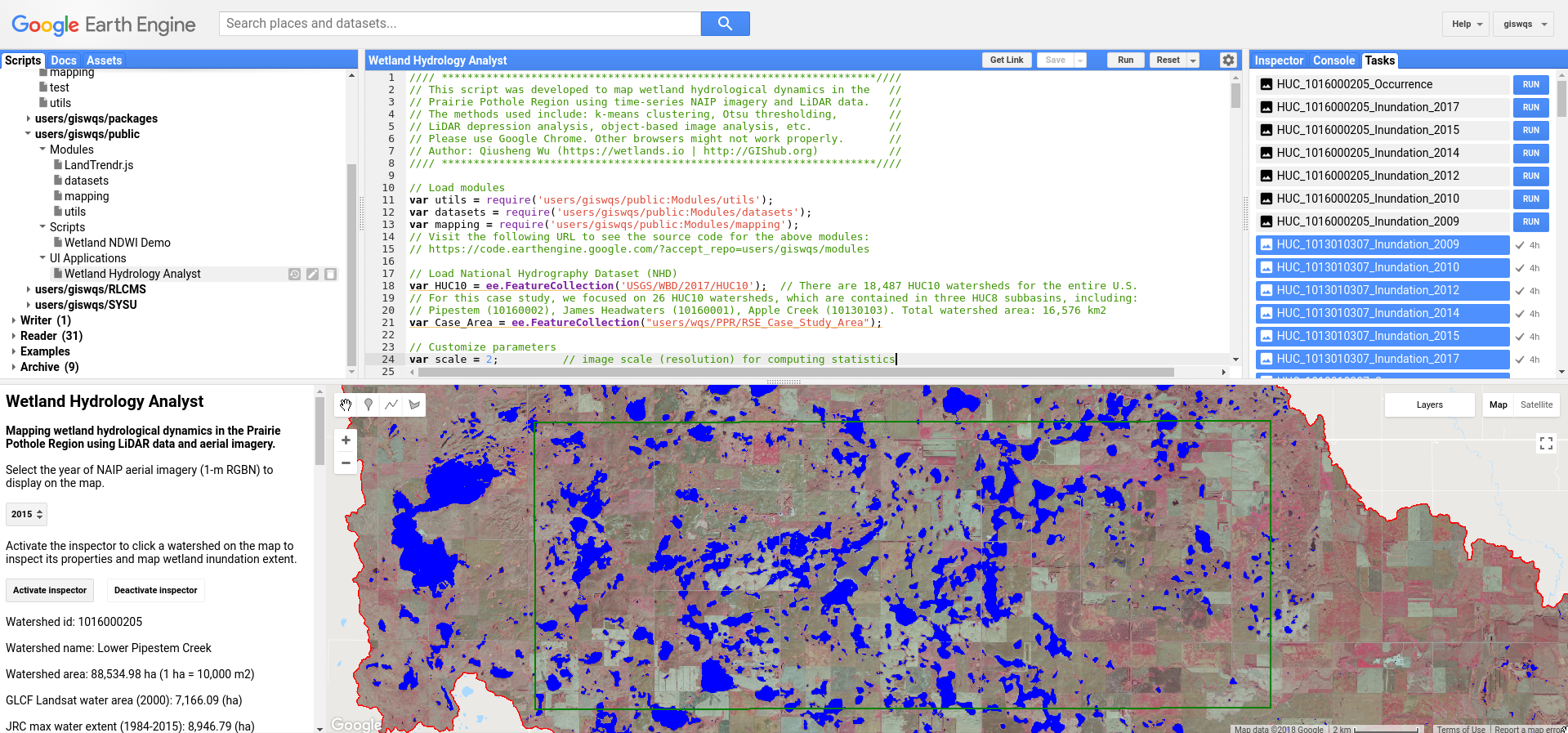
We have developed a GUI application (Wetland Hydrology Analyst) for mapping wetland inundation dynamics using multi-temporal aerial imagery and LiDAR data. To access the application, visit this URL: https://wqs.users.earthengine.app/view/wetland-hydro-gee
To view the Google Earth Engine source code for this application, visit this URL: https://gishub.org/2018-RSE-GEE-Code
Google Earth Engine Interface
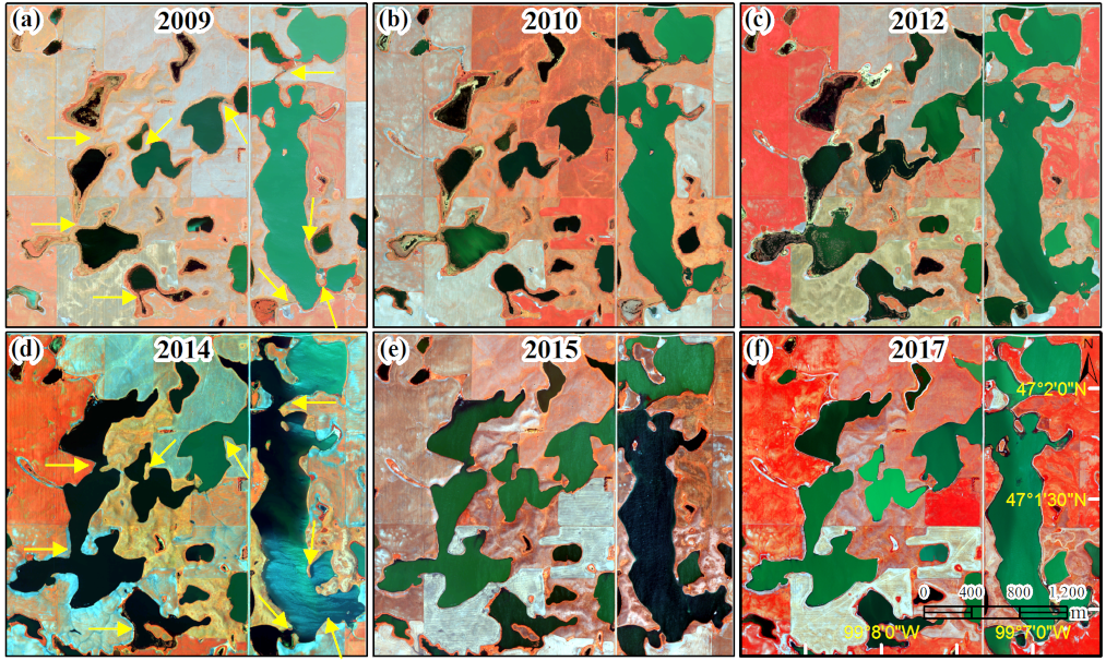
Multi-temporal NAIP aerial imagery (1-m) in the Prairie Pothole Region
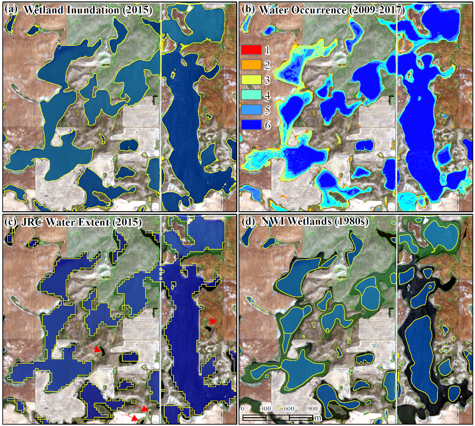
Comparison of wetland inundation maps
Note that the project description data, including the texts, logos, images, and/or trademarks,
for each open source project belongs to its rightful owner.
If you wish to add or remove any projects, please contact us at [email protected].