All Projects → vvoovv → Blender Osm

vvoovv / Blender Osm

One click download and import of OpenStreetMap and terrain for Blender! Global coverage! Source code is in the branch 'release'.

Projects that are alternatives of or similar to Blender Osm

blender-terrain
Terrain import is now a part of the blender-osm addon. Get it for free at https://gumroad.com/l/blender-osm
Stars: ✭ 28 (-95.24%)
Mutual labels:  blender, addon, terrain, import
Blendergis
Blender addons to make the bridge between Blender and geographic data
Stars: ✭ 4,642 (+689.46%)
Mutual labels:  blender, addon, openstreetmap
Xnalaramesh
Blender addon Import/Export XPS Models, Poses
Stars: ✭ 262 (-55.44%)
Mutual labels:  import, blender, addon
3D-Public-Transport-Simulator
The 3D Public Transport Simulator is a Unity-based simulation, which uses OpenStreetMap data in order to support the simulation of worldwide locations. The development was part of a Bachelor thesis.
Stars: ✭ 87 (-85.2%)
Mutual labels:  blender, openstreetmap, osm
Vectiler
A vector tile, terrain and city 3d model builder and exporter
Stars: ✭ 394 (-32.99%)
Mutual labels:  terrain, osm, openstreetmap
blender-xray
STALKER (aka xray-engine) import/export plugin for Blender 3D
Stars: ✭ 132 (-77.55%)
Mutual labels:  blender, addon, import
accessibility-cloud
👩🏽‍🦯🦮👩🏻‍🦽👩🏿‍🦼 the platform to exchange physical accessibility data in a standardized, future-proof, easy-to-use way.
Stars: ✭ 37 (-93.71%)
Mutual labels:  openstreetmap, osm
basemaps
Scripts to generate MapServer mapfiles based on OpenStreetMap data. Please submit pull requests to the 'main' branch.
Stars: ✭ 51 (-91.33%)
Mutual labels:  openstreetmap, osm
is-osm-uptodate
Find outdated nodes in OpenStreetMap
Stars: ✭ 16 (-97.28%)
Mutual labels:  openstreetmap, osm
Hootenanny
Hootenanny conflates multiple maps into a single seamless map.
Stars: ✭ 264 (-55.1%)
Mutual labels:  osm, openstreetmap
o.map
Open Street Map app - KaiOS
Stars: ✭ 51 (-91.33%)
Mutual labels:  openstreetmap, osm
Openstreetmap Heatmap
Visualization of OpenStreetMap Data with Blender and Python
Stars: ✭ 261 (-55.61%)
Mutual labels:  blender, openstreetmap
Tilemill
TileMill is a modern map design studio
Stars: ✭ 2,952 (+402.04%)
Mutual labels:  osm, openstreetmap
bexhill-osm
A local mapping project using data from OpenStreetMap. Includes overlays, walking directions and historical information.
Stars: ✭ 16 (-97.28%)
Mutual labels:  openstreetmap, osm
MapComplete
A small and easy OpenStreetMap editor
Stars: ✭ 101 (-82.82%)
Mutual labels:  openstreetmap, osm
Osrm Backend
Open Source Routing Machine - C++ backend
Stars: ✭ 4,716 (+702.04%)
Mutual labels:  osm, openstreetmap
IOR reference
A Blender addon that display IOR values in a list
Stars: ✭ 19 (-96.77%)
Mutual labels:  blender, addon
Mesh mesh align plus
Precisely align, move, and measure+match objects and mesh parts in your 3D scenes.
Stars: ✭ 350 (-40.48%)
Mutual labels:  blender, addon
Bpy
blender python scripts
Stars: ✭ 441 (-25%)
Mutual labels:  blender, addon
query-overpass
Query the OpenStreetMap Overpass API.
Stars: ✭ 17 (-97.11%)
Mutual labels:  openstreetmap, osm

blender-osm: OpenStreetMap and terrain for Blender

blender-osm provides one click download and import of OpenStreetMap and real world terrain data for Blender with global coverage. Two versions of the addon are available:

They are briefly described below.

blender-osm (premium)

In addition to the features of the base version, the premium one provides:

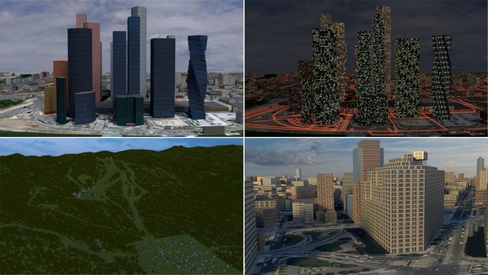
  • Import of buildings from OpenStreetMap with default materials, tileable building textures and UV-mapping applied
  • Default materials and textures to mimic lit windows for a late evening setting
  • Import of forests and single trees as 3D objects
  • Options to use custom tileable building textures (e.g. from textures.com)
  • Satellite imagery and web maps projected on a terrain

Buy the addon at gumroad.com! By purchasing the addon you support the addon development. All customers will get the addon source code under GPL license! All default textures and materials supplied with addon are released under the CC0 (public license)!

The detailed documentation is available here.

blender-osm (the base version)

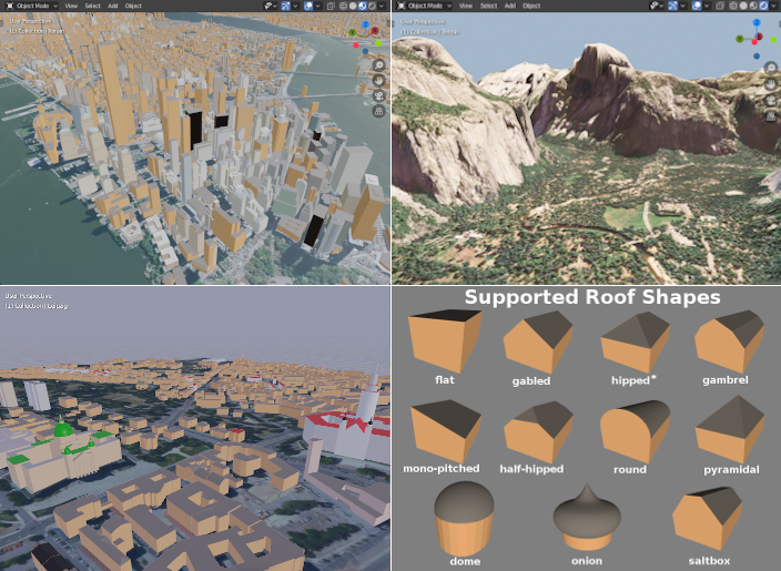
  • blender-osm imports buildings from OpenStreetMap without any texture applied. Building height and number of floors are used to create the final scene. Composition into 3D parts for a building with the complex structure is also processed. A large number of roof shapes is supported. If a terrain is provided, buildings are placed on the terrain automatically.
  • blender-osm downloads and imports real world terrain data with resolution about 30 meter.
  • blender-osm can import GPX-tracks and project them on the terrain.
  • River, lakes, forests, vegetation are imported as polygons. If a terrain is provided, they are projected on the terrain.
  • Imported roads, paths and railways have width. They are represented by Blender curves with a profile object. If a terrain is provided, roads are projected on the terrain.

Get the addon at gumroad.com! You might prefer to pay some price for the addon to support its development. However it is completely optional. The addon source code is available under GPL license!

The detailed documentation is available here.

Links and contacts

Note that the project description data, including the texts, logos, images, and/or trademarks, for each open source project belongs to its rightful owner. If you wish to add or remove any projects, please contact us at [email protected].