MapsuiMapsui is a .NET Map component for WPF, Xamarin.Forms, Xamarin.Android, Xamarin.iOS and UWP
Stars: ✭ 447 (-90.37%)
Mutual labels: gis, geospatial, map, openstreetmap
OpenglobusJavaScript 3d maps and geospatial data visualization engine library.
Stars: ✭ 199 (-95.71%)
Mutual labels: 3d, gis, geospatial, map
L7🌎 Large-scale WebGL-powered Geospatial Data Visualization analysis framework which relies on Mapbox GL or AMap to render basemaps.
Stars: ✭ 2,517 (-45.78%)
Mutual labels: 3d, gis, geospatial, map
Geotiff.ioStatic website for viewing and analyzing GeoTIFF's in the browser
Stars: ✭ 53 (-98.86%)
Mutual labels: raster, gis, geospatial, map
BforartistsBforartists is a fork of the popular 3D software Blender, with the goal to improve the UI.
Stars: ✭ 240 (-94.83%)
Mutual labels: 3d, blender, addon
OsmnxOSMnx: Python for street networks. Retrieve, model, analyze, and visualize street networks and other spatial data from OpenStreetMap.
Stars: ✭ 3,357 (-27.68%)
Mutual labels: gis, geospatial, openstreetmap
GrassGRASS GIS - free and open source Geographic Information System (GIS)
Stars: ✭ 281 (-93.95%)
Mutual labels: raster, gis, geospatial
localtileserver🌐 dynamic tile server for visualizing rasters in Jupyter with ipyleaflet or folium
Stars: ✭ 190 (-95.91%)
Mutual labels: geospatial, gis, raster
CesiumAn open-source JavaScript library for world-class 3D globes and maps 🌎
Stars: ✭ 8,095 (+74.39%)
Mutual labels: 3d, gis, geospatial
GeoNotesA simple app to create georeferences notes.
Stars: ✭ 37 (-99.2%)
Mutual labels: openstreetmap, gis, georeferencing
Election GeodataPrecinct shapes (and vote results) for US elections past, present, and future
Stars: ✭ 289 (-93.77%)
Mutual labels: geospatial, shapefile, map
Mesh mesh align plusPrecisely align, move, and measure+match objects and mesh parts in your 3D scenes.
Stars: ✭ 350 (-92.46%)
Mutual labels: 3d, blender, addon
Blender autotrackerBlender autotracker addon
Stars: ✭ 47 (-98.99%)
Mutual labels: 3d, blender, addon
pyGISS📡 A lightweight GIS Software in less than 100 lines of code
Stars: ✭ 114 (-97.54%)
Mutual labels: geospatial, gis, shapefile
georaster-layer-for-leafletDisplay GeoTIFFs and soon other types of raster on your Leaflet Map
Stars: ✭ 168 (-96.38%)
Mutual labels: geospatial, gis, raster
3D-Public-Transport-SimulatorThe 3D Public Transport Simulator is a Unity-based simulation, which uses OpenStreetMap data in order to support the simulation of worldwide locations. The development was part of a Bachelor thesis.
Stars: ✭ 87 (-98.13%)
Mutual labels: blender, openstreetmap, geodata
pylandtempAlgorithms for computing global land surface temperature and emissivity from NASA's Landsat satellite images with Python.
Stars: ✭ 110 (-97.63%)
Mutual labels: geospatial, geodata, raster
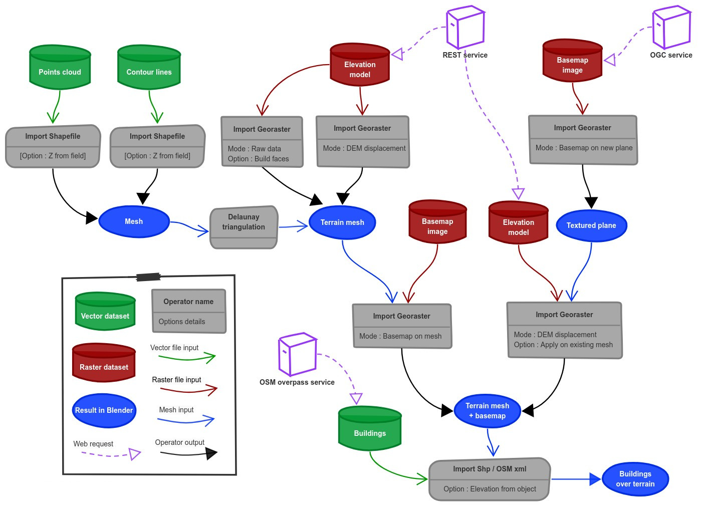
Blender OsmOne click download and import of OpenStreetMap and terrain for Blender! Global coverage! Source code is in the branch 'release'.
Stars: ✭ 588 (-87.33%)
Mutual labels: blender, addon, openstreetmap
Go GeomPackage geom implements efficient geometry types for geospatial applications.
Stars: ✭ 456 (-90.18%)
Mutual labels: 3d, gis, geospatial