ArduPilot / Octomapplanner
Projects that are alternatives of or similar to Octomapplanner
.. _octomapplanner-gazebo-sitl:
============ OctomapPlanner
This article explains how to set up and use ArduPlanner to work with Gazebo SITL
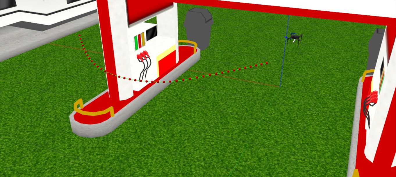
.. image:: https://discuss.ardupilot.org/uploads/default/original/3X/f/1/f1618477d5558a5b77a186b81b52ae4e84345c09.jpg :target: https://discuss.ardupilot.org/uploads/default/original/3X/f/1/f1618477d5558a5b77a186b81b52ae4e84345c09.jpg
Overview
OctomapPlanner is a library for autonomous mapping and planning specifically designed for ArduPilot Copter. It uses Octomap for 3D occupancy mapping and OMPL and FCL for goal-directed planning with collision avoidance.
.. warning::
This library is still under development and has only been tested to work with Gazebo SITL for limited test cases. Further development and tests on hardware are still to be done.
Setup Instructions
It is recommended to use Ubuntu 16.04 since all the tests have been conducted on it.
Make sure to install gazebo-8 instead of gazebo-7 since visualization messages are not supported before gazebo-8
Users should first setup OSRF keys and install Gazebo 8 by executing
::
sudo sh -c 'echo "deb http://packages.osrfoundation.org/gazebo/ubuntu-stable `lsb_release -cs` main" > /etc/apt/sources.list.d/gazebo-stable.list'
wget http://packages.osrfoundation.org/gazebo.key -O - | sudo apt-key add -
sudo apt update
sudo apt install libgazebo8-dev
We will also use ros sources for installing other dependencies. To do that use the following commands
::
sudo sh -c 'echo "deb http://packages.ros.org/ros/ubuntu $(lsb_release -sc) main" > /etc/apt/sources.list.d/ros-latest.list'
sudo apt-key adv --keyserver hkp://ha.pool.sks-keyservers.net:80 --recv-key 421C365BD9FF1F717815A3895523BAEEB01FA116
sudo apt update
.. tip::
ROS users can also install Gazebo 8 with ROS support after adding OSRF keys and using ros-kinetic-gazebo8-* packages
Follow the steps here to install ardupilot_gazebo https://github.com/swiftgust/ardupilot_gazebo
Dependencies Installation
octomap
::
sudo apt install liboctomap-dev
mavlink
::
sudo apt install ros-kinetic-mavlink
OMPL
::
sudo apt install ros-kinetic-ompl
fcl
::
git clone https://github.com/danfis/libccd
cd libccd
mkdir build && cd build
cmake -G "Unix Makefiles" -DBUILD_SHARED_LIBS=ON ..
make && sudo make install

git clone https://github.com/flexible-collision-library/fcl
cd fcl
mkdir build
cd build
cmake ..
sudo make install
Finally, build OctomapPlanner and copy the iris model and grass model for gazebo to find
::
git clone https://github.com/ardupilot/OctomapPlanner
cd OctomapPlanner
mkdir build
cd build
cmake ..
make
cp -r ../models/* ~/.gazebo/models/
Running the code
Launch Gazebo with a demo world by executing
::
gazebo --verbose worlds/iris_gas_station_demo.world
On a seperate terminal start ArduCopter SITL
::
sim_vehicle.py -v ArduCopter -f gazebo-iris
Switch the copter to guided mode and takeoff using the following commands
::
mode guided
arm throttle
takeoff 1 (or any other hight in metres)
Before launching the code you may want to edit a few parameters like start and goal location This can be done by editing the planner_params.yaml file inside the config folder
Finally, launch the planner code by executing this from the OctomapPlanner root folder
::
./build/main_node
Related Blogs
GSoC 2018: Realtime Mapping and Planning for Collision Avoidance <https://discuss.ardupilot.org/t/gsoc-2018-realtime-mapping-and-planning-for-collision-avoidance/29864>_
GSoC 2018: Realtime Mapping and Planning for Collision Avoidance: Part 2 <https://discuss.ardupilot.org/t/gsoc-2018-realtime-mapping-and-planning-for-collision-avoidance-part-2/30750>_