All Projects → koide3 → Hdl_people_tracking

koide3 / Hdl_people_tracking

Licence: bsd-2-clause
Real-time people tracking using a 3D LIDAR

Labels

Projects that are alternatives of or similar to Hdl people tracking

direct lidar odometry
Direct LiDAR Odometry: Fast Localization with Dense Point Clouds
Stars: ✭ 202 (+24.69%)
Mutual labels:  ros, lidar
Interactive slam
Interactive Map Correction for 3D Graph SLAM
Stars: ✭ 372 (+129.63%)
Mutual labels:  ros, lidar
lidar body tracking
ROS Catkin package to track people using octree and cluster extraction
Stars: ✭ 68 (-58.02%)
Mutual labels:  ros, lidar
lidar-sync-mimics-gps
Open-Source LiDAR Time Synchronization System by Mimicking GPS-clock
Stars: ✭ 52 (-67.9%)
Mutual labels:  ros, lidar
Loam velodyne
Laser Odometry and Mapping (Loam) is a realtime method for state estimation and mapping using a 3D lidar.
Stars: ✭ 1,135 (+600.62%)
Mutual labels:  ros, lidar
patchwork
Official page of Patchwork (RA-L'21 w/ IROS'21)
Stars: ✭ 174 (+7.41%)
Mutual labels:  ros, lidar
Hdl localization
Real-time 3D localization using a (velodyne) 3D LIDAR
Stars: ✭ 332 (+104.94%)
Mutual labels:  ros, lidar
teraranger
Ros nodes for single TeraRanger sensors
Stars: ✭ 19 (-88.27%)
Mutual labels:  ros, lidar
Hdl graph slam
3D LIDAR-based Graph SLAM
Stars: ✭ 945 (+483.33%)
Mutual labels:  ros, lidar
Lidar camera calibration
ROS package to find a rigid-body transformation between a LiDAR and a camera for "LiDAR-Camera Calibration using 3D-3D Point correspondences"
Stars: ✭ 734 (+353.09%)
Mutual labels:  ros, lidar
Opensimplelidar
Open Source scanning laser rangefinder
Stars: ✭ 2,206 (+1261.73%)
Mutual labels:  ros, lidar
Awesome Robotic Tooling
Tooling for professional robotic development in C++ and Python with a touch of ROS, autonomous driving and aerospace.
Stars: ✭ 1,876 (+1058.02%)
Mutual labels:  ros, lidar
urban road filter
Real-time LIDAR-based Urban Road and Sidewalk detection for Autonomous Vehicles 🚗
Stars: ✭ 134 (-17.28%)
Mutual labels:  ros, lidar
Depth clustering
🚕 Fast and robust clustering of point clouds generated with a Velodyne sensor.
Stars: ✭ 657 (+305.56%)
Mutual labels:  ros, lidar
Lego Loam
LeGO-LOAM: Lightweight and Ground-Optimized Lidar Odometry and Mapping on Variable Terrain
Stars: ✭ 1,138 (+602.47%)
Mutual labels:  ros, lidar
Lidar camera calibration
Light-weight camera LiDAR calibration package for ROS using OpenCV and PCL (PnP + LM optimization)
Stars: ✭ 133 (-17.9%)
Mutual labels:  ros, lidar
Rosonwindows
ROS on Windows Documentation Repository
Stars: ✭ 147 (-9.26%)
Mutual labels:  ros
Pyicp Slam
Full-python LiDAR SLAM using ICP and Scan Context
Stars: ✭ 155 (-4.32%)
Mutual labels:  lidar
Self Driving Golf Cart
Be Driven 🚘
Stars: ✭ 147 (-9.26%)
Mutual labels:  ros
Industrial ci
Easy continuous integration repository for ROS repositories
Stars: ✭ 146 (-9.88%)
Mutual labels:  ros

hdl_people_tracking

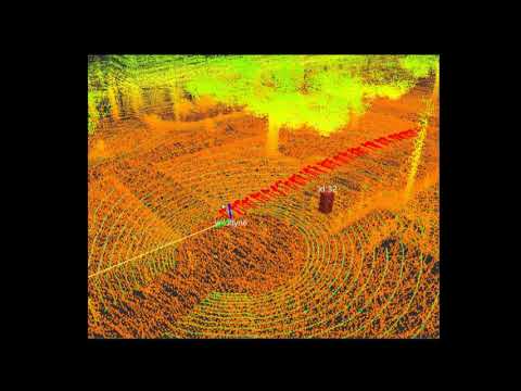
hdl_people_tracking is a ROS package for real-time people tracking using a 3D LIDAR. It first performs Haselich's clustering technique to detect human candidate clusters, and then applies Kidono's person classifier to eliminate false detections. The detected clusters are tracked by using Kalman filter with a contant velocity model.

Video:
hdl_people_tracking

Requirements

hdl_people_tracking requires the following libraries:

  • OpenMP
  • PCL 1.7

The following ros packages are required:

Example

Bag file (recorded in an outdoor environment):

rosparam set use_sim_time true
roslaunch hdl_people_tracking hdl_people_tracking.launch
roscd hdl_localization/rviz
rviz -d hdl_localization.rviz
rosbag play --clock hdl_400.bag

[NOTE]:

If it doesn't work well, change ndt_neighbor_search_method in hdl_localization.launch to "DIRECT1". It makes the scan matching significantly fast, but a little bit unstable.

If your bagfile is static (velodyne device is fixed) try with the following launch file without any localization needs:

rosparam set use_sim_time true
roslaunch hdl_people_tracking hdl_people_tracking_static.launch

Related packages

Papers

Kenji Koide, Jun Miura, and Emanuele Menegatti, A Portable 3D LIDAR-based System for Long-term and Wide-area People Behavior Measurement, Advanced Robotic Systems, 2019 [link].

Contact

Kenji Koide, [email protected]

Active Intelligent Systems Laboratory, Toyohashi University of Technology, Japan [URL]
Robot Innovation Research Center, National Institute of Advanced Industrial Science and Technology, Japan [URL]

Note that the project description data, including the texts, logos, images, and/or trademarks, for each open source project belongs to its rightful owner. If you wish to add or remove any projects, please contact us at [email protected].